There appear to be few maps
of Pennsylvania made from the 1690's into the 1730's. There is a
gap from Thomas Holme to Lewis Evans and Benjamin Eastburn which
no mapmaker rose to fill. However, the state continued to appear
in European atlases.
 |
1690.1
PENSILVANIA, from John Seller's A New System of
Geography. This map is listed by Dunlap and Burden #673.
The first edition appeared in 1685 and did not have this
map, although it did have a map of North America naming
Pennsylvania. This 1690 geography also contains the map
of New Iarsey that appeared in the 1682 Atlas
Maritimus. This appears to be the last map prepared
specifically for Pennsylvania until the 1730's. This map
also appeared in the Atlas Terrestris circa 1700.
Longitude is east from Ferro, blank verso. Scale: 1 inch
= 24 miles. Size: 5 x 6 inches. |
| |
1690.2 A NEW MAP
OF NEW ENGLAND AND ANNAPOLIS WITH THE COUNTRY'S ADJACENT
by Richard Daniel (McCorkle #690.1). This map is a
revision of the 1679 Daniel map and contains an inset of
Boston harbor. |
| |
1690.3 NORTH
AMERICA DIVIDED INTO ITS 111 PRINCIPALL PARTS 1ST ENGLISH
PART VIZ ENGLISH EMPIRE CONTAINING .... N YORK N JARSEY
PENSYLVANIA MARYLAND..... by Philip Lea? (McCorkle #690.3).
This map includes the Caribbean and is only listed here
because Pennsylvania appears in the title. |
 |
1691.1 NOVA
SVECIA...,
by Peter Lindstrom (Lindestrom).
This map was discussed in the Introduction and shows the
location of Swedish settlements on the Delaware River. It
is reproduced in the 1925 translation of Lindstrom's Geographia
Americae which is the image shown here, and in The
Annals of America, Vol. 1 page 303 (see Adler).
Peter Lindstrom circa 1655 made
a map titled Nova Svecia, anno 1654 och 1655, Ardenna
Novae Sveciae Carta Med, dess Riviers och Landz situation
ock, Beskaffenhet Aftagen ock till Carts, ford af P.
Lindstrom. In 1759, Israel Acrelius published (in Swedish)
a book titled Description of the former and present
condition of the Swedish Church in what was called New
Sweden, afterwards New Netherland, but at the present
time Pennsylvania... He made the following comments
on the Lindstrom map: "Said Engineer Lindstrom's
description of New Sweden, which was placed in the Royal
Archives, was accompanied by a map of all the places
known upon the Swede's river. The map begins at the mouth
and extends up to the falls, upon both sides of the river.
(Here Acrelius gives a long list of every place name on
the map.) The aforesaid map was of the length of four
ells, and two ells in breadth, and until the year 1696,
when His Royal Majesty King Charles XI renewed the
Swedish mission in America, was hung up in the Royal
Council Chamber in the castle at Stockholm. Then the King
directed that this map should be copied off in smaller
form and engraved on copper, whereby it was preserved
from the destruction which overtook the castle in
Stockholm by the lamentable fire of the year 1697. A copy
of this is found in Th. Camp. Holm's Description of New
Sweden." According to the OED, the ell varied in
length from country to country with the English ell being
45 inches, and the Flemish 27 inches. In any case, the
original map was apparently quite large and no longer
exists. Lindstrom left the copy shown here in manuscript
form when he died in 1691. The map has north at the
bottom, depicts only the Delaware River, and names many
of the Swedish and Dutch settlements along its banks.
Thomas Campanius
published it in a translation of Martin Luther's Catechism
in 1696 with the title Novae Sveciae, which may have been
the 1696 engraving mentioned by Acrelius.
In 1702 Campanius retitled the
map across the top 'Nova Svecia hodie dicta Pensylvania'
for his book
Kort Beskrifning om
Provincien nya Swerige, Stockholm, S. Wankijfsankia
, retaining the rest of
Lindstrom's original imprint on the bottom.
Since Lindstrom left
these maps for his Geographia in manuscript form
at his death in 1691, this date is used for them. In the
preface to his translation of Lindstrom, Johnson provides
a biography and says that the manuscript was probably
prepared after 1683, when Lindstrom entered a long
illness that lasted up to his death in 1691. |
 |
1691.2 NOVA
SUECIA:CLLER THE SMENSKA REVIER IN INDIA OCCIDENTALIS,
drawn by Peter Lindstrom, Royal Swedish Engineer; 1654
& 1655. Sometime after 1655, back in Sweden from
America, Lindstrom worked on Geographia Americae.
He died in 1691 leaving his Geographia, which
included several maps, in manuscript form, thus 1691 is
used here as the date for these maps. The original
manuscript is now in the
Riksarkivet, Stockholm. This
image is from the 1925 translation of the Geographia
and is the second of two maps of the Delaware River which
Lindstrom made. In
1874 The Historical Society of Pennsylvania published a
translation of Acrelius's book with the title A
History of New Sweden. The introduction to this 1874
book has the following comment: "The valuable map
which accompanies the volume has been engraved from a
facsimile copy, made for Mr. Mickley, from the original
of Peter Lindstrom, the Royal Swedish Engineer."
This map differs from the other Lindstrom map in title,
proportion and in having north at the right; most of the
place names appear the same. Size: 23 x 6 inches.
|
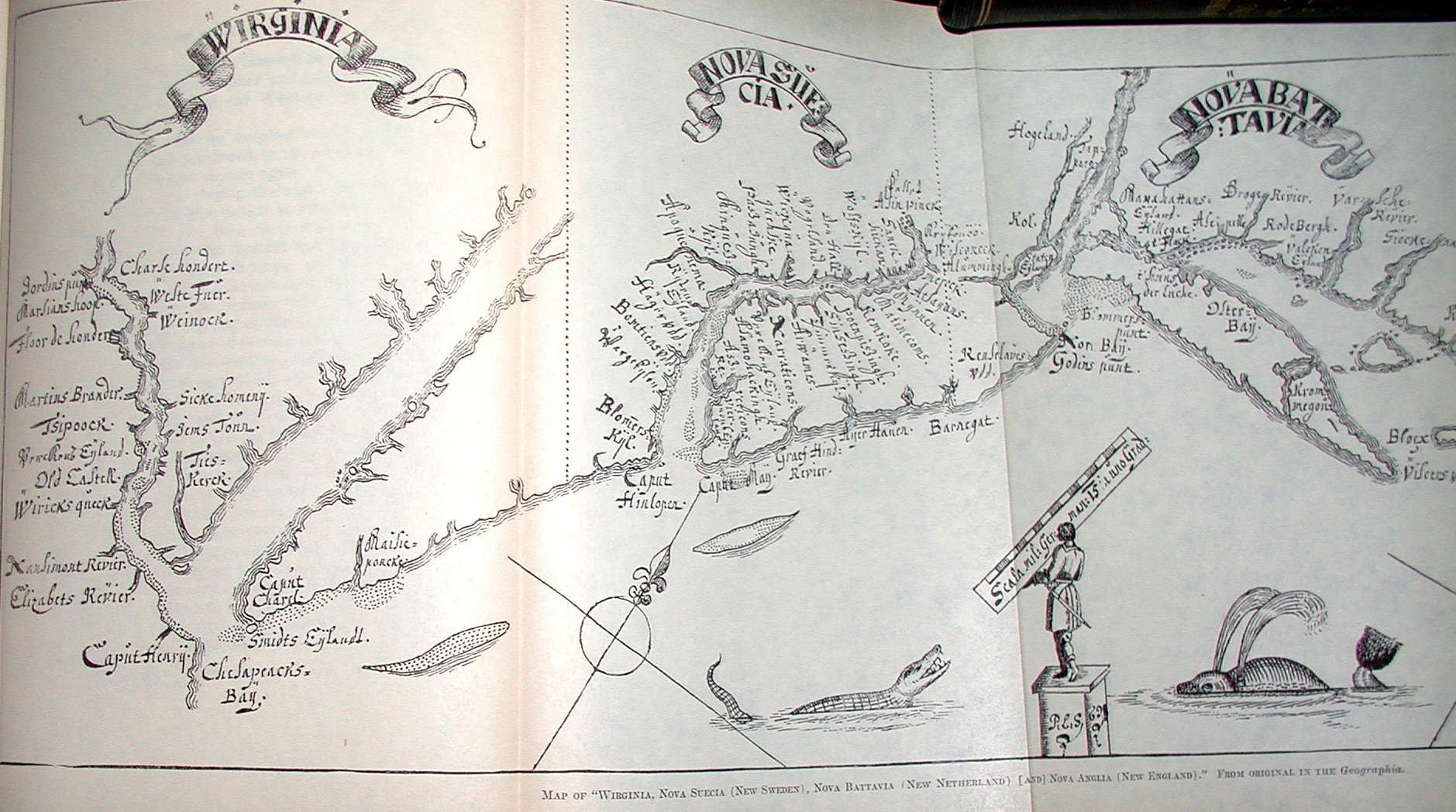 |
1691.3 WIRGINIA,
NOVA SUECIA, NOVA BATTAVIA, NOVA ANGLIA, by Peter
Lindstrom in his Geographia Americae, reprinted
with translation by Amandus Johnson, The Swedish Colonial
Society, Philadelphia 1925, from which the image here is
taken. This
image shows only the left, or southern, half of the map
which includes Pennsylvania. Lindstrom also prepared a
map of Fort Christina (present day Wilmington) which
appeared in the Geographia
but does
not include anything of Pennsylvania (see Garrison,
Dunlap). The Fort Christina map also appears in The
Annals of America, Vol. 1 page 303 (see Adler). |
| |
1692.1 CANADA
HALT IN FICH, by Johann Ulrich Muller, Frankfurt 1692.
This is a very small map number IV (~3 x 3 inches, Burden
#689 who says the maps are untitled) from Muller's
miniature atlas Geographia Totius Orbis Compendiaria.
It shows eastern North America from Hudson Bay to the
Chesapeake, and must come from an old plate because
Pennsylvania is not named but N. Sucecia and Christina
are named. There are two other maps V, VI (Burden #690,
691) which include the Pennsylvania region. The maps are
similar to those of Duval, maps 1660.1-3, and later
Hoffman, map 1678.2. McCorkle #692.1, #692.2, identifies
two maps from Muller's Kurtz-bundige Abbild- und
Vorstellung der gantzen Welt, published in Ulm 1692,
which are apparently the same as the maps IV, V except
have titles. |
| |
1692.2
VIRGINISCHE PASKAART..., by Jacobus Robyn (Burden #693).
This map is a Dutch version of Hermann's 1673 map and
first appeared in 1684 in a Van Keulen atlas under a
different name. A later 1717 version is reproduced in
Papenfuse & Coale, who discuss its history. The map
includes southeastern Pennsylvania. |
 |
1693.1 LA
LOVISIANA, PARTE SETTENTRIONALLE, by Vincenzo Coronelli (Burden
#701). This is a beautiful map of the Great Lakes region.
The Pennsylvania area is covered by the scale with no
detail. Coronelli is most known for his globes, and globe
gores of the Pennsylvania region (i.e. east coast) are
sometimes seen dated in the 1690's. Image from the
Heritage Map Museum CD by permission. Burden #734
reproduces a 1697 reduced version of this map from
Coronelli's Isolario, Venice 1697. |
| |
1693.2 CARTE
PARTICULIERE DE VIRGINIE, MARYLAND, PENNSILVANIE, LA
NOUVELLE IARSEY ORIENT ET OCCIDENTALE, by Nicolas Sanson,
Amsterdam : Chez P. Mortier. A nautical chart with depths
shown by soundings, this map covers the coasts of
Virginia, Maryland, Delaware, New Jersey, and waterways
of eastern Pennsylvania. It appears in Le Neptune
françois, ou, Atlas nouveau des cartes marines, in
various editions, and is oriented with north to the right.
Listed in Dunlap and in Burden #766 dated circa 1700;
later versions are sometimes attributed to A. Jaillot,
see Map #200J5 in the Maryland State Archives. A 1696
version is reproduced in Papenfuse & Coale. |
 |
1694.1
NOVA BELGICA ET ANGLIA NOVA by Jansson, Jan, Valk &
Schenk. circa 1694, dated 1695 by Dunlap. This map is
based on the de Laet map of 1630. The first state of the
Jansson map was issued in 1636, this image is state 3,
see Burden #247. The copper plate was sold at auction in
1694 and purchased by Petrus Schenk who issued the map
under his own name. Image from the Heritage Map Museum CD
by permission. |
| |
1695.1 A NEW MAP
OF THE ENGLISH EMPIRE IN AMERICA . VIZ. VIRGINIA,
MARYLAND, CAROLINA, NEW YORK, NEW IARSEY, NEW ENGLAND
PENNSYLVANIA NEWFOUNDLAND NEW FRANCE &C. by Rob:
Morden, I. Harris sculp; sold by Robt. Morden and
Christopher Brown (McCorkle #695.3, Burden #750 who dates
it circa 1698). There is also a 1706 version and a later
version appears in 1719 from John Senex. This map
contains insets of the North Atlantic and Boston Harbor.
It is illustrated in Pritchard & Taliaferro #68
Custis Atlas. |
 |
1695.2 CARTE
NOUVELLE DE L'AMERIQUE ANGLOISE CONTENANT LA VIRGINIE,
MARY-LAND, CAROLINE, PENSYLVANIA NOUVELLE IORCK, N:
IARSEY N:FRANCE, ET LE TERRES NOUVELLEMENT DECOUERTE
DRESSE SUR LES RELATIONS LES PLUS NOUVELLES PAR LE SIEUR
S A AMSTERDAM CHEZ PIERRE MORTIER LIBRAIRE AVEC PRIVILEGE
DE NOS SEIGNEURS LES ETATS. by Nicolas Sanson, in
additions of the Neptune Francois and other
Sanson atlases per McCorkle #695.7, also in Jaillot's Atlas
Nouveau. The dating of this map is uncertain and
this image from the LOC is dated 1700; also described in
Burden #765 dated 1700. It shows eastern North America
from Hudson Bay to Florida on two sheets, only the
Pennsylvania region is shown here. Philadelphia and Bucks
County are identified, as are "Penasburg,"
Philadelphia, Darby, and Chester. In the interior, the
"Susquehana R." and fort are named and the
Indian tribe "Sinneks." |
| |
1695.3 (Delaware
County) A 19th century reproduction of a manuscript map
dated circa 1695 was seen for sale. It shows the area
near the town of Chester at the confluence of (apparently)
Chester Creek and the Delaware River with the land
divided up into properties with the holders names. An
inscription reads "Chester Pt R Long C Puzey James
Sunderland & others." The original is said to be
held by a Thos. Darlington; whether it still exists is
not known. |
 |
1696.1 NOVAE
SVECIAE, by
Peter Lindstrom (also Lindestrom, Lindhestrom). This map
was discussed above for 1691 and shows the location of
Swedish settlements on the Delaware River.
Peter Lindstrom in 1655 made a
map titled Nova Svecia, anno 1654 och 1655, Ardenna Novae
Sveciae Carta Med, dess Riviers och Landz situation ock,
Beskaffenhet Aftagen ock till Carts, ford af P. Lindstrom.
This map
burned in 1697 but not before an engraving was made, as
mentioned by Acrelius, which Thomas Campanius published
in a translation of Martin Luther's Catechism in
1696. This
translation into Indian language had been made by
Campanius' grandfather, Johann, circa 1660. In 1702
Campanius retitled the map across the top 'Nova Svecia
hodie dicta Pensylvania' for another book.
This map is listed by
Dunlap, Burden #721.
Image courtesy of the State
Library of Pennsylvania. |
| |
1696.2 CANADA
SIVE NOVA FRANCIA, a playing card map from a series
issued by Johann Hoffman, Nuremburg 1696 (Burden #715).
The same series contains NOVVM BELGIUM ET NOVA SUETIA (Burden
#716) and VIRGINIA (Burden #717). All are crude maps
similar to the previous small Hoffman maps 1678.2. |
| |
1697.1 DAS
ENGLISHCHE AMERICA by Richard Blome from a book of the
same name, Leipzig 1697 (McCorkle #697.1, Burden #736).
This is a German version of the R.B. map 1685.3 with the
printer mistakenly ascribing the R. B. to Richard Blome. |
 |
1697.2 CARTE D'UN
TRES GRAND PAIS NOUVELLEMENT DECOUVERT DANS L'AMERIQUE
SEPTENTRIONALE ENTRE LE NOUVEAU MEXIQUE ET LA MER
GLACIALE AVEC LE COURS DU GRAND FLWUVE MESCHASIPI by
Louis Hennepin from various editions of Hennepin's
voyages published from 1697 to 1711 (Burden #739;
McCorkle #697.3, #704.3, who illustrates another
continental version of the map also). Despite its title
this map shows only the eastern United States (and
southern Canada). It was made to show the Great Lakes and
the course of the Mississippi and is the progenitor of
the maps later made famous by de Lisle and de Vaugondy.
McCorkle illustrates four versions of this map, English,
French, German, and Spanish. Philadelphia is named and
Pennsylvania is located in New Jersey. This image is from
the National Archives of Canada and the map can be viewed
at Historical
Maps -- James Ford Bell Library
. There is also a large
reproduction in Johnson (1974) and another version is
reproduced in
Winsor
. |
 |
1698.1
PENNSYLVANIA AND WEST JERSEY. This map by Philip Lea,
London, is from An Historical and Geographical Account
of the Province and Country of Pennsylvania and of West-New-Jersey
in America by Gabriel Thomas, published by A. Baldwin,
London 1698. The book was reprinted in 1848 by H. A.
Brady, New York (see page 671 of Phillips), and in 1935
by A. M. Aurand Jr., which is the image shown here. This
map also appeared in Lea's atlas Hydrographia
Universalis or The Sea Coasts of the Known Parts of the
World, London 1700 as shown here; and in a German edition of
Thomas, Continuatio der beschreibung der landschafft
Pensylvaniae, Frankfurt and Leipzig 1702; see
Docktor
#200L2, #202B5. Burden #728
dates this map circa 1696 from its appearance in the Hydrographia
Universalis. There were several 17th century
accounts of Pennsylvania written; Penn himself wrote at
least 8 versions of his Some Account of the Province
of Pennsylvania... . In 1685 appeared Good Order
Established in Pennsilvania & New-Jersey in America, by
Thomas Budd and printed by Philadelphia's first printer,
William Bradford. In 1692 Bradford also printed A
Short Description of Pennsylvania by Richard Frame.
Around 1700 Francis Daniel Pastorius published Umständige
Geographische Beschreibung der zu allerletzt erfundenen
Provintz Pensylvaniae ... (A Particular Geographical
Description of the lately discovered Province of
Pennsylvania); indicative of the early German
settlement. |
| |
1698.2 CHARTE
EINES SEHR GROSSEN LANDES.... by Louis Hennepin, the
German version of the 1697 map (McCorkle #698.3, Burden #747).
There is also a 1699 German version (McCorkle #699.3). |
| |
1698.3 A MAP OF A
LARGE COUNTRY.... by Louis Hennepin, the English version
of the 1697 map (McCorkle #698.4, Burden #745). A portion
is reproduced in Brown, No. 8. |
| |
1698.4 A CHART OF
THE SEA COAST OF NEW FOUND LAND, NEW SCOTLAND, NEW
ENGLAND, NEW YORK, NEW JERSEY, with VIRGINIA and MARYLAND,
by Iohn Thornton hydrographer (McCorkle #698.6). This sea
coast map appears in The English Pilot, The Fourth
Book of 1698. Pennsylvania is not in the title but
is named on the map, no detail is given. McCorkle (#749.2)
lists a pirated copy published in 1749 by George Grierson; and Mount and Page also published a copy in 1750 with minor changes.
|
| |
1698.5 THE
PROVINCE OF NEW YORK IN AMERICA AND THE TERRITORIES
ADJACENT, a manuscript map of uncertain date drawn by
Augustin Graham, the Surveyor General of New York. This
map is reproduced in Swift (2001) dated 1698. It shows
the Hudson and the Delaware Rivers. Details of settlement
are shown for the Hudson, but not for the Delaware. |
| |
1698.6 ACCURATA
DELINEATIO CELEBERRIMAE REGIONIS LUDOVICIANAE VEL GALLICE
LOUISIANE OL. CANADAE ET FLORIDAE ADPELLATIONE IN
SEPTEMTRIONALI AMERICA 1698. This map of eastern North
America was seen in an apparent reproduction for sale. No
reference has yet been found and it is not in McCorkle or
Burden. The map bears the same title, though shortened,
as the 1730 one by Suetter and closely resembles the 1719
map by de Fer, including the inset of the Gulf coast but
not the inset of Quebec. The best guess (for now) is that
the map is a copy of the 1719 de Fer map and the 1698
date is symbolic. Stay tuned. |
| |
1698.7
PHILADELPHIA CITY LETTER P. DRAFT OF LETITIA'S FRONT LOTT,
in Warrants and Survey Returns 2:101,2; Philadelphia City
Archives, record series 225.3. A manuscript map showing
two streets next to the river and the lot assigned to
William and Letitia Penn. Reproduced in M. P. Snyder,
Figure 7. |
| |
1699.1 CARTA
GEOGRAPHICA DE UN PAIS QUE NUEVAMENTE.... by Louis
Hennepin, the Spanish version of the 1697 map (McCorkle #699.2).
|
| |
1699.2
A MAP OF THE ENGLISH POSSESSIONS IN NORTH AMERICA AND
NEWFOUNDLAND AS IT WAS PRESENTED AND DEDICATED TO HIS
MOST SACRED MAJESTY KING WILLIAM 1699. A manuscript map
in the Library of Congress listed in Phillips page 564,
and illustrated in Hayes Map 64. Pennsylvania and
Philadelphia are both named. |
