Pennsylvania did not exist
prior to 1681, however these early maps show settlement in the
region or were important in setting the boundaries of the state.
Maryland's colonies were on the Chesapeake, Plowden never
established any colony in New Jersey, and Dutch settlement on the
Delaware was reduced to occasionally manned trading posts, since
the main area of Dutch settlement was on the Hudson. So, the
first permanent settlement in what is now Pennsylvania was by the
Swedes. They landed along the Brandywine in 1638 and established
a colony at Fort Christina (Wilmington). They extended
settlements north to the Schuylkill River and from circa 1640 on,
Swedish, Dutch, and English fur traders and farmers were settling
at various points along the Delaware in what would become
Pennsylvania, see Johnson and Weslager.
A famous map of North America
was published in 1650 by Nicolas Sanson. He was among the first
to make use of the Jesuit Relations, the detailed
reports prepared by the Jesuit missionaries infiltrating New
France. California remains an island and the entire west and
north of the continent is a blank.
 |
1650.1 PASCAERTE
VAN NIEV NEDERLANT... . Burden (#297) considers this sea
chart by Theunis Jacobsz to be the first Dutch sea chart
of their new colony. The date of 1650 is used because
Jacobsz died then. Three place names are given along the
Delaware River, 'F. Naffau', 'Der hal', and 'Verhulft Eyl'.
The first is obviously Fort Nassau and the map reflects
Dutch, rather than Swedish, control of the river. This
chart can be seen at
MapForum.Com
, Issue 2. McCorkle (#666.4)
dates this map to 1666 when it first appeared in the Nieuwe
water-werelt, ofte Zee-atlas. This image is the
second state dated 1677 from the National Archives of
Canada; however Burden and McCorkle date the second state
to 1681. The major difference is an engraved cartouche
added at lower right. |
| |
1650.2 (East
Coast) An untitled manuscript map prepared in 1650 by
John Farrer of the Virginia Company still survives today
in the New York Public Library. It is illustrated on
Plate 327 in Cumming, Skelton & Quinn, and differs
considerably from the 1651 printed version based upon it
described below. |
 |
1651.1 A MAP OF
VIRGINIA DISCOUERED TO YE FALLS... This map (Burden #303)
appeared in 1651, and is based upon the manuscript map
prepared in 1650 by John Farrer of the Virginia Company
which still survives today in the New York Public Library.
This could be considered a continental map because the
west coast is shown just beyond the Appalachian Mountains
with Sir Francis Drake's landing illustrated. However, it
is clearly derived from John Smith's map and shows the
coastal region from 'Hudfons' to 'Ca. Feare'. 'Lord
Delawars Bay and river' are named with the note: 'This
Riuer the Lord Ployden hath a Patten of and calls it new
Albion but the Sweeds are planted in it and haue a great
trade of Furrs.' The 'Safquehanakes Riuers' is shown
emptying into the 'Checepiacke'. Cape May is called 'Cape
James'. The Hudson is shown connecting to the St.
Lawrence River leading to a 'A Mighty great Lake'. This
map is also reproduced in Stephenson & McKee. It
exists in several states; this image was published by John Overton circa
1667 and is from the Library of Congess. Some later
versions of the map were titled A MAP OF VIRGINIA
DISCOVERED TO YE HILLS. |
| |
1651.2 BELGII
NOVI ANGLIAE NOVAE ET PARTIS VIRGINIAE, published by
Joannes Jansson in 1651. As Burden (where the map is #305)
says: "this map must be ranked as one of the
fundamental prototype maps of America." It was
reproduced for over a hundred years by a succession of
Dutch cartographers from Jansson to Lotter, and the
series is discussed by Tony Campbell in Chapter 8 of
Tooley. The map shows the coast quite accurately from
Maine to the Chesapeake, however the interior is unknown
and even the Great Lakes are not shown. The Delaware
upstream is connected to the Hudson, but the Susquehanna
is shown for the first time in reasonable form, and with
a pair of large Indian villages surrounded by palisades
just west of it. Mohicans, Senecas, Matanacs, and other
tribes are identified. The Swedish settlements Fort
Chriftina and Uplandt are identified along with several
other settlement and stream names. Present day Cape
Henlopen is placed too far south and its place taken by 'C.
Cornelius', a mistake that would have consequences for
Delaware and Maryland. A 1657 version is reproduced in
Fite & Freeman and several derivatives of this famous
map are included here. |
| |
1651.3 VIRGINIA
NIEU NEDER-LANDT NEW ENGELANDT. Also in 1651 appeared
this map by Joost Hartgers (Burden #304) showing the
coast from Maine to Carolina. The Dutch names along the
Delaware are used including 'Fort Naffau' and also 'Chriftina',
the Swedish settlement at Wilmington. There is an inset
of Bermuda. |
 |
1651.4 VON VIRGINIA. 389. This title and number are at top. The cartouche title is 'VIRGINIA.' This map is one of the many versions of the John Smith map. It replaced the 1628 version (see 1628.1) of Gerard Mercator and is from the German edition of the Atlas Minor of 1651, long after Mercator's death (1512-1594). This map was first published in the 1648 edition per Burden, who also shows this 1651 copy as an example (plate 287 in Burden), see map 1648.3. The Flemish engraver and cartographer Jodocus Hondius (1563-1612), bought Mercator's plates, and published a reduced version of Mercator's folio Atlas Sive Cosmographis, and added some of his own maps. A pocket version, the Atlas Minor, was published by Cornelius Claesz and Johannes Janssonius in several editions extending past Hondius' death into the mid 1600s. Despite its small size, it is filled with towns with both English and native names, including Jamestown (Jamestowne). The area of Pennsylvania is undefined. There are no latitude markings and the longitude is apparently given from Ferro. Intaglio print. Scale: 1 inch ~ 50 miles. Size: 5.75 x 7.75 inches. |
| |
1652 |
 |
1653.1
LE CANADA FAICT PAR LE LR CHAMPLAIN. OU SONT LA NOUVELLE
FRANCE, LA NOUVELLE ANGLETERRE, LA NOUVELLE HOLANDE, LA
NOUVELLE SVEDE, LA VIRGINIE... by Pierre Duval (Burden #309).
Burden discusses an untitled map (Burden #188) dated
circa 1616 and believed to be a proof copy pulled from a
plate used by Pierre Duval for this map, which also is in
Schwartz & Ehrenberg. The original map is attributed
to Champlain but Duval has added considerably more names
and identities. The Delaware is called 'R. de Sud' which
is the Dutch name for it. This image is from the National
Archives of Canada. A version dated 1664 (McCorkle #664.1)
can be seen at Pugsley
Maps from
McGill University and a 1677 version (McCorkle #677.1)
can be seen at The
Cartographic Creation of New England
, an exhibit at the Oscher Map
Library. |
| |
1654 |
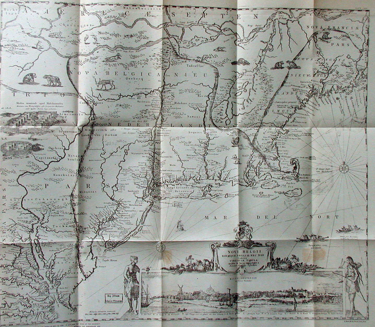 |
1655.1 NOVI
BELGII NOVAEQUE ANGLIAE NEC NON PARTIS VIRGINIAE TABULA
by Nicolaas Visscher. Around 1655, Visscher's version (Burden
#315) of the 1651 Jansson map appeared with this slightly
different title, although there is apparently some debate
whether this map was prepared first though published
later. Burden relates an interesting note concerning
William Penn as follows: "...an example of the
second state (which Burden dates circa 1656) was used in
the first boundary dispute between William Penn and Lord
Baltimore of Maryland. It resides today in the John Work
Garrett Library and bears lines marking the settled
border as ordered by the Privy Council in 1685.
Unfortunately the map placed Cape Henlopen some twenty-five
miles too far south, creating a source for future discord.
Penn's own writing on the reverse identifies it."
This note by Penn on the back of the map is reproduced in
Papenfuse & Coale. The Jansson-Visscher maps are
illustrated at MapForum.Com
, Issue 13, and also discussed
in an article by Campbell in Tooley, where a third state
of the Visscher map is mentioned. The 1655 state of the
map is rare according to Burden and this image is from a
rather poor reproduction in Mathews of a later version. |
| |
1655.2 (East
Coast) Weslager mentions two maps titled A Chart of the
Coast-line from Virginia to New England, and A Chart of
the South Bay, dating both circa 1630-40. They were
published in 1912 as a supplement to the Linschoten-Vereeniging
edition of de Vries, Korte Historiael,
Colenbrander (Ed.); these maps are also listed by Dunlap.
The Korte Historiael ende Journaels aenteyckenvnge...
(Short Historical and Journal Notes) by David
Pietersz De Vries is a small quarto volume with
illustrations published in 1655. It has been reprinted in
English in historical compilations (usually without maps)
several times. The editor for the New York Historical
Society Second Series, Vol. III Part 1 (1857), had this
to say about its maps: "We cannot say anything in
favor of the plates connected with his voyages to America.
They are for the most part copied from Champlain, and
look indeed very much like the identical plates used to
illustrate an edition of his voyages to Canada." De
Vries was involved in the Dutch settlement near Lewes in
1631 that was wiped out by the Indians. He explored the
Delaware circa 1631-32. More recently, these maps are
reproduced in Burden (2007) and would appear to be based
upon early Dutch charts rather than Champlain, i.e. the
Vingboons maps 1639.1-4 which themselves were likely
based upon explorations by De Vries. The coastline map is
untitled and nothing local is identified; it is similar
to the Colom map 1656.1 below. The Delaware map is titled
PAS-CAART VAN DE SUYD - RIVIER IN NIEW NEDERLAND, and
indicates "Swanendael" (i.e. Lewes) along the
Delaware coast and "Fort Naffouw" in New Jersey,
and nothing else. It is similar to the Vingboons maps of
the Delaware. |
 |
1656.1 PASCAARTE
VAN NIEU NEDERLANDT... In the year 1656 Arnold Colom
published Zee-Atlas, ofte Water-Wereldt, which
contains this chart (Burden #316) of the region from Cape
Cod to Carolina. Delaware Bay is reasonably shown with
the capes named and also the 'Schuyl Kil', kil means
river or stream in Dutch. Nothing inland is identified.
This chart can be seen at
MapForum.Com
, Issue 2, and also in Issue 7
where a compilation of Colom's sea atlas is presented.
The image here is from Stokes. |
 |
1656.2 NOVA
BELGICA SIVE NIEUW NEDERLANDT. This map (Burden #317)
appears in the second edition of the book Beschryvinge
van Nieuw-Nederlant by Adriaen van der Donck,
however Burden ascribes the map to the publisher Evert
Nieuwenhof since the author had died. It is centered on
the Hudson River but the upper Delaware appears along the
left edge, and the map is actually an excerpt from the
Jansson-Visscher map. A number of place names along the
river are identified including 'Finlant' which documents
the little known Finnish attempt at settlement. Campbell
(in Tooley Chapter 8) mentions three later states of this
map. There is a large reproduction of this map in Johnson
(1974). This image is from Winsor. |
 |
1656.3 LE CANADA
OU NOUVELLE FRANCE &C. by Nicolas Sanson (Burden #318)
is an excerpt from his continental map of 1650. It
depicts the region from Labrador to Georgia. Lakes
Ontario, Erie, and 'Superieur' have their present names,
but Lake Huron is 'Karegnon Di' and Lake Michigan 'Lac de
Puans'. This image is from the National Archives of
Canada. A reduced version of this map (Burden #325)
appeared in L'Amerique en plusieurs cartes
published in 1657. This map can be seen at Pugsley
Maps from
McGill University. One of the most interesting features
of the map is its division of the Delmarva peninsula
setting off the Swedish settlements. This is the earliest
map seen setting up such a division which later on became
so important a boundary question between Maryland,
Delaware, and Pennsylvania. |
| |
1656.4 Sometime
circa 1656 as dated by Burden (#322), appears a curiosity
of a map by Pierre Duval. It is titled L'AMERIQVE, but is
a set of small maps showing portions of the continent.
The one titled 'La Virginie' shows the Pennsylvania
region. |
| |
1657.1 In 1653
Francesco Bressani published a book describing his years
as a Jesuit missionary in New France. (The movie 'Black
Robe' brilliantly depicts the experiences of a French
Jesuit in this era.) The map that was to accompany the
book was issued in 1657 and titled NOVAE FRANCIAE
ACCURATA DELINEATIO 1657 (Burden #323). It depicts the
region from the St. Lawrence to Carolina. Lakes Ontario
and Erie are named, Huron is called 'Mare Dvlce'.
Delaware Bay is indicated and the region called 'Nova
Svecia', showing French knowledge of the Swedish
settlements. The western half of this map is reproduced
in Portinaro & Knirsch, Plate XCII. |
| |
1657.2 LE CANADA
OU NOUVELLE FRANCE &C. by Nicolas Sanson (Burden #325),
A reduced version of Sanson's 1656 map which appeared in
the atlas L'Amerique en plusieurs cartes
published in 1657. This map appeared in many later
editions using Sanson maps, see 1683 for example. |
 |
1657.3 The same
Sanson atlas contained another map titled LA FLORIDE (Burden
#326). The latitude extends north to 40 degrees and Lake
Erie is positioned three degrees too far south. A
derivative of this map (Burden #352) by Pierre Duval
appeared in 1660. The image shown here is from the
Library of Congress. |
| |
1658 |
| |
1659
|


