 The 1950's
and 60's were the peak years for oil company road maps. Many
small oil companies still operated and they seemingly all issued
maps, but that also meant no one much needed the general road
maps and they began disappearing.
The 1950's
and 60's were the peak years for oil company road maps. Many
small oil companies still operated and they seemingly all issued
maps, but that also meant no one much needed the general road
maps and they began disappearing. | WELCOME | 1950's Road Maps of Pennsylvania | WELCOME |
The 1950's
and 60's were the peak years for oil company road maps. Many
small oil companies still operated and they seemingly all issued
maps, but that also meant no one much needed the general road
maps and they began disappearing.
 |
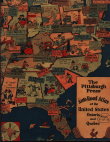
1950 1950 WEEK-END MOTOR TOURS, suggested by the Pittsburgh Post-Gazette. copyright 1950, P-G Publishing Company. This is a 28 page booklet with maps and trip descriptions for local trips outside Pittsburgh; such as this trip to Deep Creek Lake in Maryland. Size: 8.5 x 5.5 inches. |
 |
1951 ALA - GENERAL DRAFTING CO. ALA stands for Automobile Legal Association, imagine lawyers putting out a road map. The association was headquartered in Boston (land of lawyers) and goes back to 1907. In the early years they put out the ALA Green Book, a written description of routes. This map includes New York and is undated. Judging by the roads (original turnpike, no interstates) it dates circa late 40's to early 50's. |
 |
1952 H. M. GOUSHA NEW REDI-MAP MAPS OF THE 48 STATES, by H. M. Gousha Co., Chicago. This is a 32 page paperback road atlas with a one page spread of Pennsylvania, Maryland, Delaware, New Jersey and Virginia. |
 |
1953 CIVIL DEFENSE ROAD MAP OF PENNSYLVANIA SHOWING PRIMARY AND SECONDARY ROADS RESERVED FOR MILITARY AND CIVIL DEFENSE USE, from a base map issued by the Department of Highways, 1940. The routes mentioned are in green and red, no other routes are shown. Insets of Philadelphia and Pittsburgh show how to get out of town fast. This will be considered a general, not state, map here though why a 13 year old base map was used is not explained. This very large map is 60 x 34 inches and only the upper central portion with the title is shown here. |
 |
1954 RAND MCNALLY ROAD ATLAS, published by Rand McNally, Chicago. This is a 112 page atlas with a plain blue hard back cover blank on the front. On the back is an ad for fasteners. What is shown here is part of the two page spread of Pennsylvania. |
 |
1955 1955 RAND MCNALLY'S REFERENCE AND ROAD ATLAS, published by Rand McNally with an advertising cover for an insurance company. This 112 page road atlas has a double page map of Pennsylvania. |
 |
1956 AAA. |
 |
1957 THE AERO RELIEF MAP OF PENNSYLVANIA, from The Aero Service Corp., Philadelphia. This large wall plastic relief map has hung in many libraries and classrooms across the Commonwealth. The geography of the state is pressed into the plastic and it is one of the earliest maps of this type. It is also a road map. Scale 1 inch = 6 miles. Size: 40 x 60 inches. |
 |
1958 PENNSYLVANIA FISH COMMISSION WATERS-HIGHWAY MAP COUNTY OF CLEARFIELD, prepared in cooperation with the Pennsylvania Department of Highways, compiled by Keystone Mapping Company of York. It is unclear if the state contracted with Keystone or Keystone got permission to use the state highway map. In any case, one of these maps for fishermen was issued for every county in the state. This is the one for the very rural Clearfield County showing roads, streams, and state forests. |
 |
1959 ROAD MAP ALLEGHENY COUNTY, PENNSYLVANIA, prepared by County Planning Commission, Pittsburgh. This map shows townships and boroughs by color, roads, and parks. There are 129 listed political entities with land area and population: one second class city (Pittsburgh), three third class cities (McKeesport, Duquesne, Clairton), 81 boroughs, 24 first class townships and 20 second class townships. Allegheny County has more independent political entities (there are now 130, a condo unit became a borough) than any county in the state by far, probably more than any other county in the nation. This large 40 x 43 inch map has a scale of 1 inch equals 1 mile, only the western section with the title is shown here. |
| General Road Maps | Early Maps | 1900's | 1910's | 1920's | 1930's |
| 1940's | 1950's | 1960's | 1970's | 1980's | 1990's |
| Home Page | Road Maps | Oil Company Road Maps | State Road Maps | References |