In addition, there are a few regional maps from
manuscript atlases which survive because they were prepared as
presentation pieces for important people, like monarchs. Most of
the manuscript and printed maps of America from this era are
world or continental maps, or also show the Caribbean and part of
South America which were the first areas settled, and so are not included.
| |
1519.1 (East Coast) This
Spanish manuscript map of the east coast by Lopo Homem is
reproduced in Johnson (1974). The crude geography and
indistinct Spanish names make it difficult to say just
what particular part of the coastline is represented, but
it may include future Pennsylvania. |
 |
1527.1 (East Coast) Winsor
describes a manuscript map in the Ambrosian Library in
Milan by Vesconte Maggiolo showing the east coast of
North America with "Tera Florida" at top and
"Lavoradore" at bottom. The information
supposedly came from Verrazano's voyage (~1524). A
facsimile of the map in Winsor is shown here. The
original was destroyed during the Second World War. |
| |
1540.1 (East Coast) There is
a map of the North Atlantic coast from an anonymous
manuscript atlas circa 1540 held at the Koninklijke
Bibliotheek, The Hague, shown as Plate 152 in Cumming,
Skelton & Quinn. |
| |
1545.1 (East Coast) A
manuscript map circa 1545 is shown as Plate 69 in Cumming,
Skelton & Quinn titled 'The land discovered by
the Pilot Estevan Gomez,' from the Islario General of
Alonso de Santa Cruz, held at the Biblioteca Nacional,
Madrid. It purportedly shows the coast from Carolina to
Newfoundland, but only the New England part is
illustrated. |
| |
1547.1 (East Coast) The Vallard
Atlas from Dieppe, described by Wallis in Images of
the World (see Wolter & Grim), contains a
regional map of North America from Labrador to Florida.
It has a large decoration of French settlers and Indians
along the bottom and south at the top. A detail from this
map is also reproduced in Portinaro & Knirsch who say
it is from a mapmaker named Pierre Descelier, and they
include another similar map dated 1544. The map,
attributed to Vallard, is also in Johnson (1974). |
 |
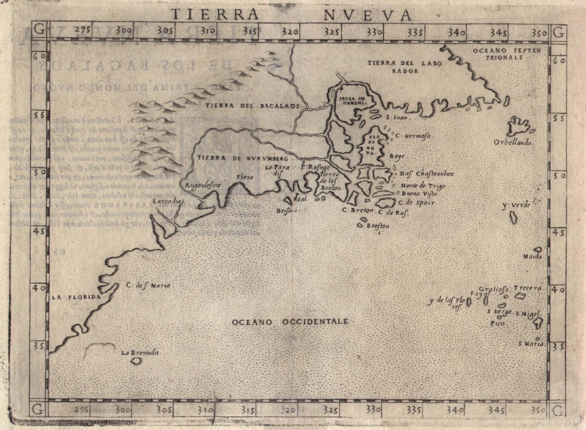
1548.1 TIERRA NVEVA by
Giacomo Gastaldi from La Geografia, his version
of Ptolemy's Geography, the first book to
contain regional maps of America and one of the first to
be engraved on copper. This is the first printed regional
map of the area that was to become Pennsylvania and is
the earliest map in Burden (Burden #16) fitting the
description of a Pennsylvania map as used here. The map
includes the east coast from Labrador to Florida, both
named. The main source for the map was the voyage of
Verrazzano in 1524, who made the Carolina coast and the
Hudson estuary, but missed both the Chesapeake and the
Delaware. Image from the Heritage Map Museum CD by
permission. |
| |
1550.1 (East Coast) This
parchment map of uncertain date appears in a mid-16th
century manuscript atlas by an unknown from the French
Dieppe group of portolan chartmakers. It shows the east
coast from Labrador to Florida. The St. Lawrence is
depicted but it is hard to recognize anything else. North
is at the bottom and and there are two beautiful ship
drawings. It is reproduced in Portinaro & Knirsch. |
| |
1556.1
LA NOUVELLE FRANCE, from the manuscript atlas Cosmographie
Universelle by Guillaume le Testu, 1556. The St.
Lawrence River is in the center of this map and the coast
trending south is called 'Coste de la Floride.' |
| |
1556.2
The same atlas contains another map called TERRA NEUVE
with the northern coast titled 'Laborador', the middle 'Terre
Neveve' printed upside down, and the southern part 'Coste
de la Flovride'. Both these maps are reproduced in
Portinaro & Knirsch. There are two other maps shown
from the atlas but they include the Caribbean and so are
not included here. |
 |
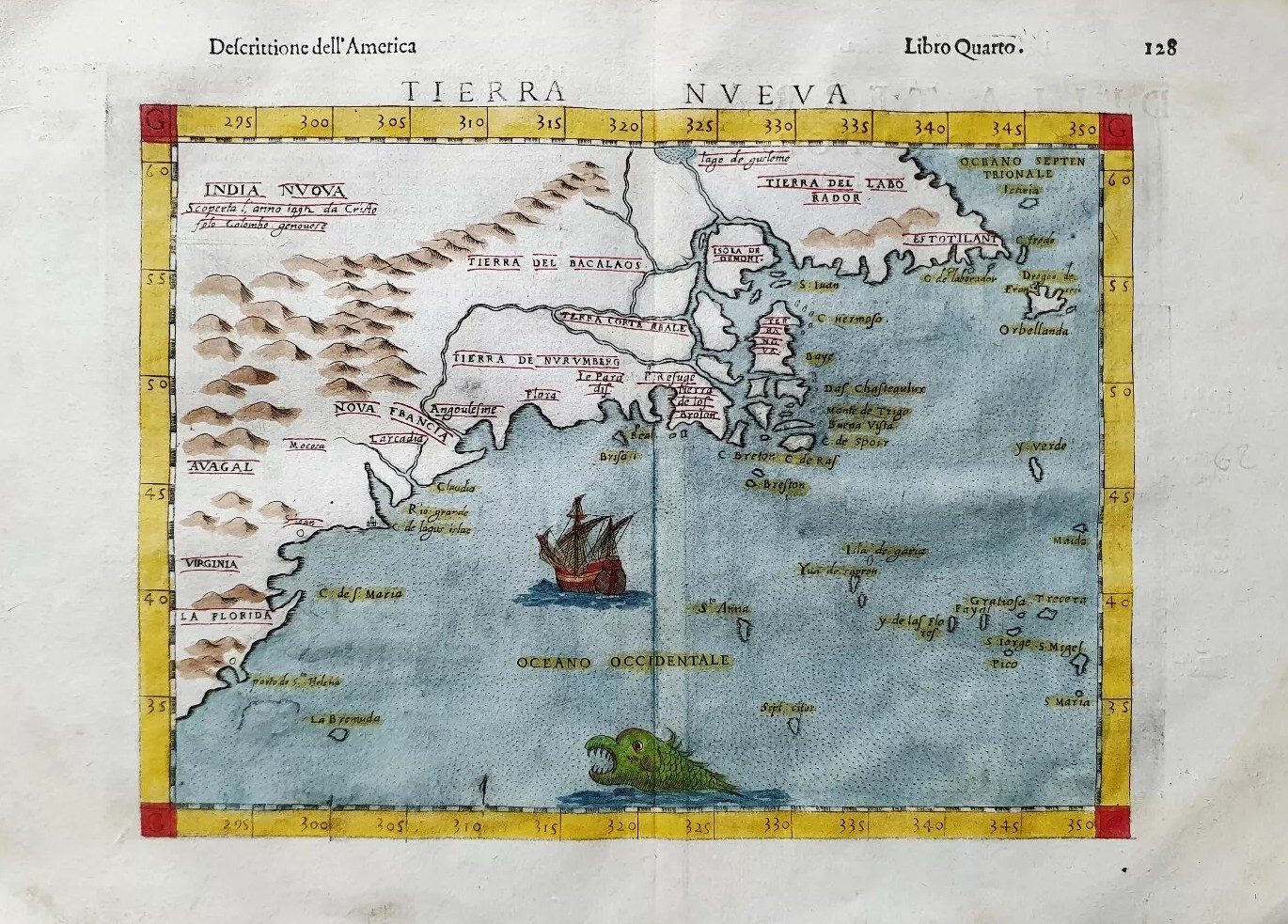
1561.1 TIERRA NVEVA, from the
Girolamo Ruscelli version of Ptolemy's Geography,
the second printed regional map of the American coast (Burden
#30). The map apparently covered two pages and a half
page of text can be seen on the verso through the paper.
The Pennsylvania region is named L'arcadia, a description
applied by Verrazzano to the wooded coast during his
voyage of 1524. This map is similar to the 1548 Gastaldi
map except for some mountains and rivers added to the
landscape. A high resolution image of this map can also
be seen at The Cartographic Creation of New England
, an exhibit at Oscher Map
Library. Both of these TIERRA NVEVA maps can be seen in
the New England map checklist at
MapForum.Com
, Issue 13. The last state of
this map appeared circa 1599 with some additional place
names added, see below. Scale: 1 inch = 350 miles. Size: 7 x 9.5
inches. |
 |
1584.1
LA FLORIDA, from the 1584 edition of
Abraham Ortelius' Theatrum
Orbis Terrarum, Additamentum III, Antwerp
1584, and later editions (Burden #57). The first
edition of this atlas in 1570 is considered the first
ever made, but lacked the addendum and this map. The
source of the map, and some others in the addendum, was
Geronimo de Chaves, the Royal Cosmographer to the King of
Spain. The map appears on a sheet with two other maps
showing Peru and the east coast of Mexico. Although the
latitude extends to 42 degrees, it can only figuratively
be said to include Pennsylvania as the area is covered by
the cartouche. This image is from the Library of Congress. |
 |
1590.1
AMERICAE PARS, NUNC VIRGINIA DICTA , PRIMUM AB ANGLIS...
by Theodore De Bry, based upon a manuscript map of John
White (Burden #76). North is to the right and the
Chesapeake Bay is wrongly oriented east-west. A piece of
Pennsylvania, by a stretch of the imagination, would be
part of the blank land area above the title cartouche and
there are no latitudinal markings to rule it out.
Theodore de Bry, in 1590, published this map based upon
information provided by John White, who was involved in
Walter Raleigh's first Roanoke Island settlement in 1585.
This group, unlike the famous later one which disappeared,
returned to England and White's sketches survived to form
the basis of the map. It shows the coast from Chesapeake
Bay to Cape Lookout. This was the most detailed map of
this region until John Smith's map of 1612. This map is
also in Stephenson & McKee and Schwartz &
Ehrenberg. An original manuscript map by John White is
reproduced in Fite & Freeman and Schwartz &
Ehrenberg. Two of White's manuscript maps are reproduced
in color in Lorant; they show the southeast coast but not
the land extending above the head of the bay as this
printed map does. White also produced a large number of
sketches and water colors of the natives and the fauna
and flora of the new world. In 1588 Thomas Hariot, also
on the Raleigh expedition, published A Brief and True
Report of the New Found Land of Virginia. De Bry
included Hariot's account and some of White's sketches
and drawings in his 1590 publication. In 1591 de Bry
published a similar volume on the 1564 French expedition
to Florida. A summary of these two publications by de Bry
is given by Lorant where all of White's original sketches
and maps are reproduced in color as well as de Bry's
engravings. The de Bry engravings of Indians have
appeared in countless histories and geographies over the
years. Image from the Heritage Map Museum CD by
permission. |
| |
1590.2
(Northeast Coast) This is an Italian manuscript
map, about 14 x 19 inches, by Jacques Dousaigo, bound in
an atlas of six charts. It shows the coastline from
Newfoundland to presumably Hatteras, nothing in the
Pennsylvania area is recognizable. It can be seen online
at Charts
and maps - National Maritime Museum, at
Greenwich. |
 |
1597.1
NORVMBEGA ET VIRGINIA, by Cornelis Wytfliet from his Descriptionis
Ptolemaicae Augmentum (Burden #103). The Virginia
capes are there from White's map, but the Chesapeake Bay
is still oriented east-west and everything north seems to
be guesswork. The Descriptionis Ptolemaicae Augmentum
contained one world map and eighteen regional maps of the
new world, so the book is sometimes called the 'first
atlas' of the Americas. Eight maps relate to North
America (Burden #100-107), this map shows the
Pennsylvania area. Chesipooc Sinus is named, placed too
far north, and the whole mid Atlantic coast is not
accurate. The image here is the state 2 version of 1607
per Burden which lacks the date under the title. Image
from the Heritage Map Museum CD by permission. |
 |
1597.2
CONIBAS REGIO CVM VICINIS GENTIBVS. Another map from
Wytfliet's Descriptionis Ptolemaicae Augmentum (Burden
#100), this map of Hudson Bay (not yet so called) extends
south to latitude 40 degrees and east to 300 degrees east
of Ferro, and so would include a chunk of Pennsylvania.
At this time nothing was known of this part of North
America; however, the map does show a large body of water
extending south into the heart of the continent. So where
did the information come from? There is another map in
Wytfliet's Descriptionis, called FLORIDA ET
APALCHE (Burden #104), which extends north to 41 degrees
and so would include the state, however the part of the
map that would be Pennsylvania territory is covered by
the map cartouche. The map is reproduced in Winsor and
that image is shown here. |
| |
1598.1 NORVMBEGA ET VIRGINIA
by Johannes Metellus. Several of the Wytfliet maps were
printed again in 1598 for a German edition of Jose de
Acosta's De Natura Nova Orbis including this
reduced version of the 1597 northeast map (Burden #118). The
maps CONIBAS REGIO CVM VICINIS GENTIBVS and FLORIDA ET
APALCHE (Burden #115, 119) also appear sans latitude and
longitude markings. |
 |
1599.1 TIERRA NVEVA. This is the last version of map 1548.1 and 1561.1 to appear, also in an edition of Ptolemy's Geography.
|