
The Courthouse (1892). Orwigsburg was the first county seat, and the first courthouse was a brick structure built there in 1816. The county seat was moved to Pottsville in 1850 and the old courthouse, at Second and Sanderson Steets, opened around 1851 and is shown in this view from the map. The present 1892 building was built in front of the old courthouse which was then demolished. This is undoubtedly the easiest courthouse in the state to find, a huge castle towering on a hilltop above downtown Pottsville in its narrow valley. This is a Romanesque style building with a square tower (huge clock face) and large arched windows. The original building is symmetric about the tower with five alternately projecting facades across the front. The annexes have been added to the left as viewed from the front. An annex was added adjacent to the courthouse in 1933, and subsequent building done in the late 1960s and around 1990 on the slope in front. Interior renovations have also been done over the years. Behind the courthouse is the jail , built in 1851 and one of the oldest in the state still in use.


The Courthouse (1915). The original courthouse was built in 1855 and enlarged in 1867. The look of the 1867 courthouse is preserved in this circa 1875 view. This courthouse was rebuilt in 1915 retaining the Classical Revival style, and in 1977 a large annex was built into the side and back. Parts of the 1855 and 1867 buildings remain underneath and to the rear of the bell tower, but are so built into by these later additions that a later dating should be used, say 1915 when the present front of the building went up. The courthouse is also tied into a commercial building (to the left in the photo) by an enclosed hallway next to the sidewalk. Apparently portions of this building were used as an annex at one time. The 1977 annex is back from the street behind a small yard and contains the present entrance.


The Courthouse (1904). The first courthouse was built in 1798. A second building was built on the present hilltop site in 1853; this building can be seen on the panoramic map. It remained in use until 1904 when the present Beaux Arts structure went up. The dome is said to be based on St. Paul's Cathedral in London, and it dominates the town. There are two entrances, one through a large and decorative Corinthian portico on the west face, and the main entrance through a matching columnar semicircular porch on the south front at the top of the hill. All of the sides project from the dome, so the building has a cruciform shape. Modern annexes sit in the next block down the hill, and fortunately are not connected. An extensive restoration, completed in 2003, left the exterior unchanged but rearranged the interior to add a third courtroom by moving ancillary courthouse functions to an annex. At an elevation of around 2200 feet above sea level, the green dome of this courthouse is the highest in the state.


The Courthouse (1894). The original building, in a brick Romanesque style, was built around the same time as the Cameron County courthouse and rather resembles it from the front. There is the large square tower to the right and the half octagon on the left. However, the center section with pointed gable and enormous arched window over the entrance is the dominant feature of this building. The front doors are no longer used, entrance is through the 1993 addition to the right rear, which is of similar brick and blends in well. It also repeats the window treatment on the older section. Some earlier 20th century additions were also made at the left rear making the courthouse as deep as it is wide. It sits in a large open lot with plenty of space around.


The Courthouse (1854). The front part of this courthouse was put up in 1854 in the Classical Revival style and a matching addition with side gable added at the back in 1883. The six Ionic columns of the portico sit above a five arch entrance. Behind the columns are five window bays with the two end bays bricked up, probably for a more balanced design. Although this courthouse looks fine from the right side, the left side and rear have been built into by utilitarian additions marring the building. Also, as the addition view shows, connecting sections to other buildings have been added into the back.


The Courthouse (1835). The county has two courthouses which sit side-by-side and are connected. The old courthouse was built in 1835 in cut stone and originally in the Federal style if the gable end is any indication. Its original shape can be seen in this circa 1840 view . In 1931 the classical portico was tacked on and an addition added to the back in yellow brick. The building to the right of the old courthouse in red brick is the old jail, now a visitor center. At some date, probably mid-twentieth century, a long red brick annex was built in back of the courthouse and jail, which is now attached to the new courthouse by an enclosed walkway. The new courthouse is also built of cut stone to match the old, although it retains the sandstone color. (The old courthouse has probably been painted many times, sandstone does not weather well.) This 1974 building is in a utilitarian, though attractive, style with a small two column portico over the recessed entrance. The entire complex of courthouses, annex, walkway, and jail occupy the whole block.


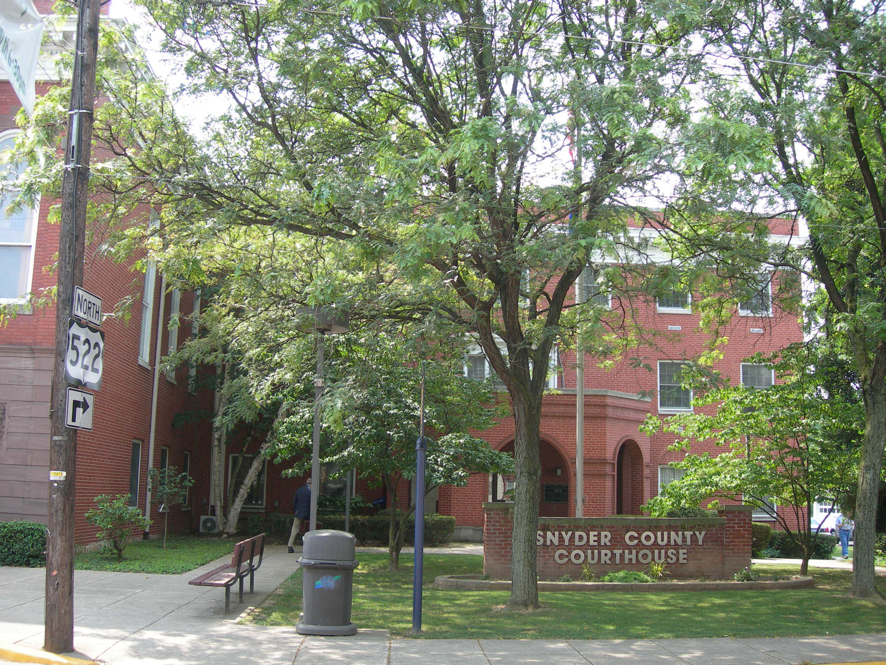
The Courthouse (1855). The original county seat was at New Berlin, subsequently moved to Lewisburg. The original part of the present courthouse was built in 1855, but later additions have so built over and into it that still using this dating is being generous. It is a Neoclassic building with a four column Ionic portico over the entrance and capped with a bell tower. The gable ends are formed as undecorated pediments, and the windows are similarly undecorated. The additions have been made at the back and to the left side viewed from the front. The last rebuilding was in 1971 when the present entrance was created.


The Courthouse (1868). The present building is the county's third courthouse, put up in 1868 as the inscribed stone above the front window says, with a rear addition in 1932 giving it a slight "T" shape. It is in an Italianate style with white trim and painted red brick. The towers are the same basic design except the taller has an inserted middle section with clock and bell, an arrangement similar to the Clinton County courthouse by the same architects. Entrance is through the front under a ballustrade decoration and bust of Benjamin Franklin. There is an unattached annex on the street behind. This courthouse sits in a large park giving it spacious grounds. Franklin has a number of attractive old homes built by lumber and oil barons of the past.


The Courthouse (1877). The photo of the 1877 courthouse can be compared to the print from the 1878 atlas, which was lithographed by Otto Krebs of Pittsburgh. This building is Second Empire style, very similar to the Elk County courthouse which had the same builder. Additions were made in 1916 and 1925, and in 1978 a new jail was attached to the 1925 section at the back. These additions do not detract too much from the look of the original as the photo shows. The courthouse sits on a large corner lot along a residential street several blocks from the downtown section of Warren.


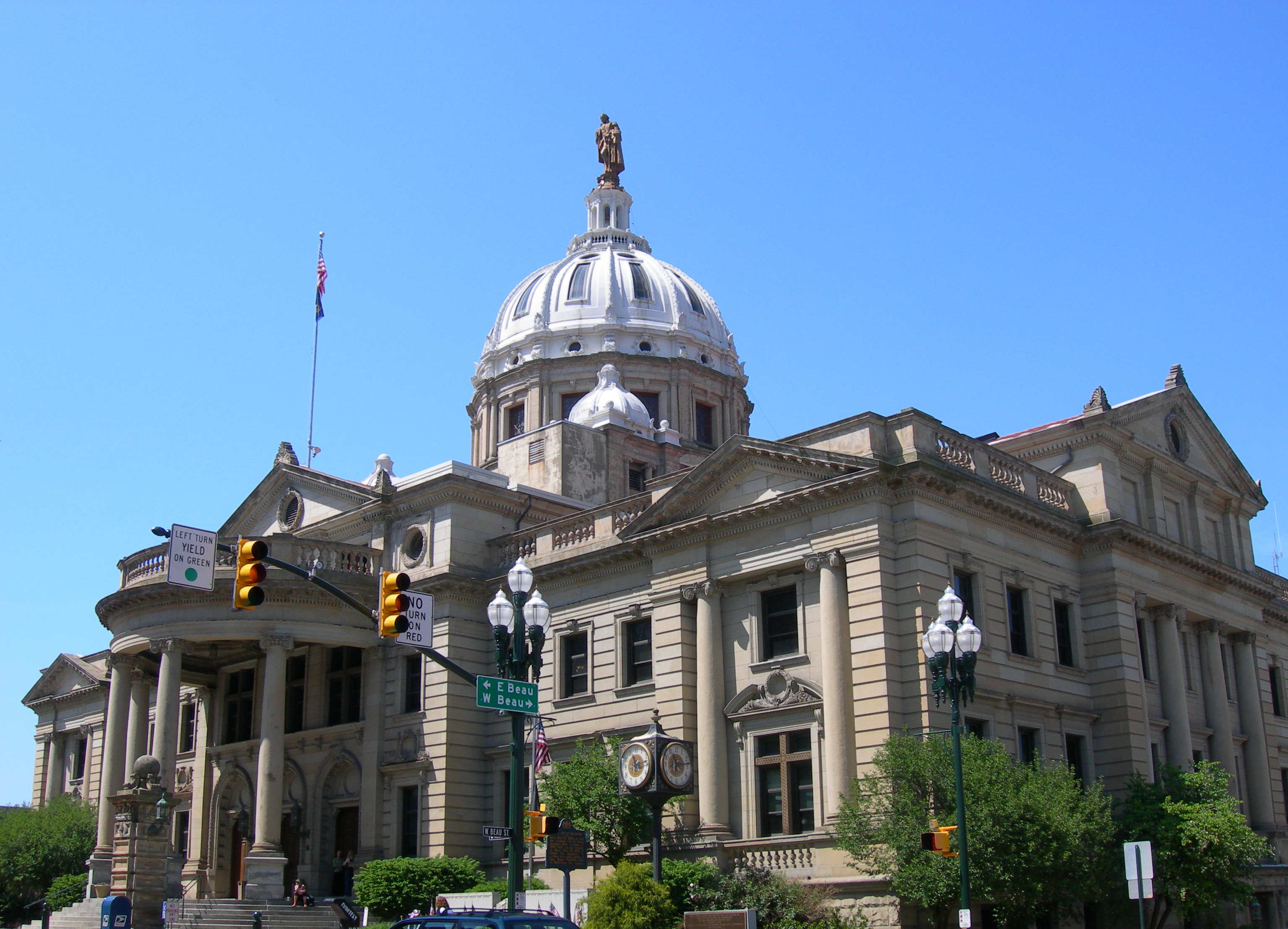
The Courthouse (1900). This is a large Beaux Arts courthouse built in 1900 and sitting on a hilltop along Main Street in downtown Washington. A statue of George Washington stands atop the dome . The back is connected to the old jail, now renovated into offices, by an enclosed walkway with an entrance. Modern unattached annexes are further down the hillside. The popularity of the Beaux Arts style is usually credited to the architecture of the Chicago World's Fair of 1893. This style was (and is) a way of making the classical style flamboyant and costly, in keeping with the rise of wealth during the Gilded Age. Washington County (and the adjacent Westmoreland) prospered with coal, coke, steel, and other industries in conjunction with Pittsburgh during the early twentieth century, and this is reflected in their courthouses.

The Courthouse (1880). This very attractive and decorative courthouse is an eclectic combination of Second Empire and Italianate styles, or perhaps a better descriptor is Victorian. The central section projects and the short tower is an upward extension of this section, which also has sets of parallel windows. The central entrance has a small porch and there are additional left and right entrances, now closed. The courthouse is as deep as wide and extends back in the form of an attenuated "H". There are decorative elements all over, around all the doors and windows, around the porch, and under the eaves. At the right rear is a modern brick annex connected through an enclosed hallway.


The Courthouse (1908). The original county seat was in Hanna's Town where several buildings, including the tavern used as the courthouse, have been reconstructed. The seat moved to Greensburg in 1787, where an existing building was used for a courthouse. The first true courthouse in Greensburg was completed in 1801, a plain brick building. A third courthouse on about the same spot was put up in 1854, and then demolished in the early 1900s. This present courthouse was completed in 1908 in a highly decorative Beaux Arts style, a larger and grander version of the Washington County courthouse. Smith & Swetnam call this architecture French Renaissance, probably due to the chateau look below the roofline and decorative stonework. The front, to the right in the picture, is no longer used; entrance is through a modern annex at the back connected to the courthouse at the rear ground floor.


The Courthouse (1870). The first court house and jail were put up in 1843, the first brick structures built in the borough. A second jail was built in 1866 and the courthouse was completely rebuilt in 1870. It was enlarged and extended to three stories with a rear projection of two stories, the whole of brick covered with cement and painted. The overall style is Italianate Tuscan Villa, capped by a high tower in proportion to the building. The central bay projects and has two very long parallel windows. The building is painted white; all the windows are trimmed and accented in brown as are the quoins at the corners and the decorative brackets under the eaves. In 1992 an addition was added to the back creating an "H" shaped courthouse. Matching trimming was added to the structure all round and it was painted to create a unified whole. Entrance today is at the rear which opens onto a small park with a memorial. Despite this incremental history, this is a very attractive building. It looks like something Frank Furness might have created whole, but didn't. (Furness was a turn of the century Philadelphia architect known for a colorful style; unfortunately he designed no Pennsylvania courthouses.)


The Courthouse (1959). The old 1840 courthouse is shown in this print from the county atlas. The present courthouse on Market Street incorporates the six Ionic columns and some foundation elements from this building. The central section with the 1840 columns was built in 1900. However, in 1959 wings were added and the central part rebuilt in brick to match, giving the present broad front Neoclassic look. So, this building as it stands is probably best dated then. Williams calls this building Beaux Arts, but it's hard to be Beaux Arts in red brick. This now old courthouse is still in use, but most courthouse functions are now centered in the new (circa 2003) York County Judicial Center around the corner on George Street. This is a huge building, taking up half the block in front and deeper than it is wide, and several stories high. It is built in what would probably be termed a Modern or Corporate style, however the arrangement of differing brick and glass boxes and the small rounded porch over the entrance give it individuality lacking in typical buildings of that label. The architects have done a good job here with a difficult problem, inserting a large new building into an older townscape without overwhelming the surroundings. This attractive building looks set to satisfy the judicial needs of the county well into the future.
