
| WELCOME | Articles on Historical Maps of Pennsylvania | WELCOME |
The Early Gulf Road Maps of Pennsylvania
by Harold Cramer
The Gulf Refining
Company was formed in 1901 by members of the Mellon family, along
with other investors, as an expansion of the J. W. Guffey
Petroleum Company formed earlier the same year. The intent was to
exploit the Spindletop oil discovery in Texas which was financed
with money borrowed from T. Mellon & Sons (i.e. Mellon Bank
of Pittsburgh). In 1907 the two companies were reorganized as the
Gulf Oil Corporation, and Guffey's shares in the two earlier
companies bought out. The company became headquartered in
Pittsburgh because of the involvement of the Mellons who remained
in charge until about 1950. Although Gulf built refineries in
Pennsylvania, it was not a Pennsylvania oil fields company; it
started too late for that. The main source of its product was
Texas, Oklahoma, and offshore Louisiana. Later on Gulf became one
of the earliest oil companies to move into the Middle East and
Venezuela and become international.
[1]
 The first generally distributed oil company
road maps are usually credited to Gulf. In 1913 they opened the first
drive-in gas station on
Baum Boulevard (shown left, along with an ad shown right) in
Pittsburgh's east end and began handing out road maps.
[2]
The early years of oil company maps, circa 1915 to 1925, are
dominated by Gulf as few other oil companies issued maps, and
until about 1925 Gulf was the only oil company to issue maps
annually. The first maps were made by W. B. Akins of Pittsburgh,
an advertising man. In 1915 the business went to the more
professional Automobile Blue Book Company; in 1922 it went to
Rand McNally who employed Harry Gousha as a salesman, and in 1927
to the newly formed H. M. Gousha company (in which Akins was an
investor). The 1915 and 1916 maps were dated. However, from 1917
to 1926 the Gulf maps carried no date or one that was not the
date of issue, and they are therefore harder to date.
[3]
The first generally distributed oil company
road maps are usually credited to Gulf. In 1913 they opened the first
drive-in gas station on
Baum Boulevard (shown left, along with an ad shown right) in
Pittsburgh's east end and began handing out road maps.
[2]
The early years of oil company maps, circa 1915 to 1925, are
dominated by Gulf as few other oil companies issued maps, and
until about 1925 Gulf was the only oil company to issue maps
annually. The first maps were made by W. B. Akins of Pittsburgh,
an advertising man. In 1915 the business went to the more
professional Automobile Blue Book Company; in 1922 it went to
Rand McNally who employed Harry Gousha as a salesman, and in 1927
to the newly formed H. M. Gousha company (in which Akins was an
investor). The 1915 and 1916 maps were dated. However, from 1917
to 1926 the Gulf maps carried no date or one that was not the
date of issue, and they are therefore harder to date.
[3]
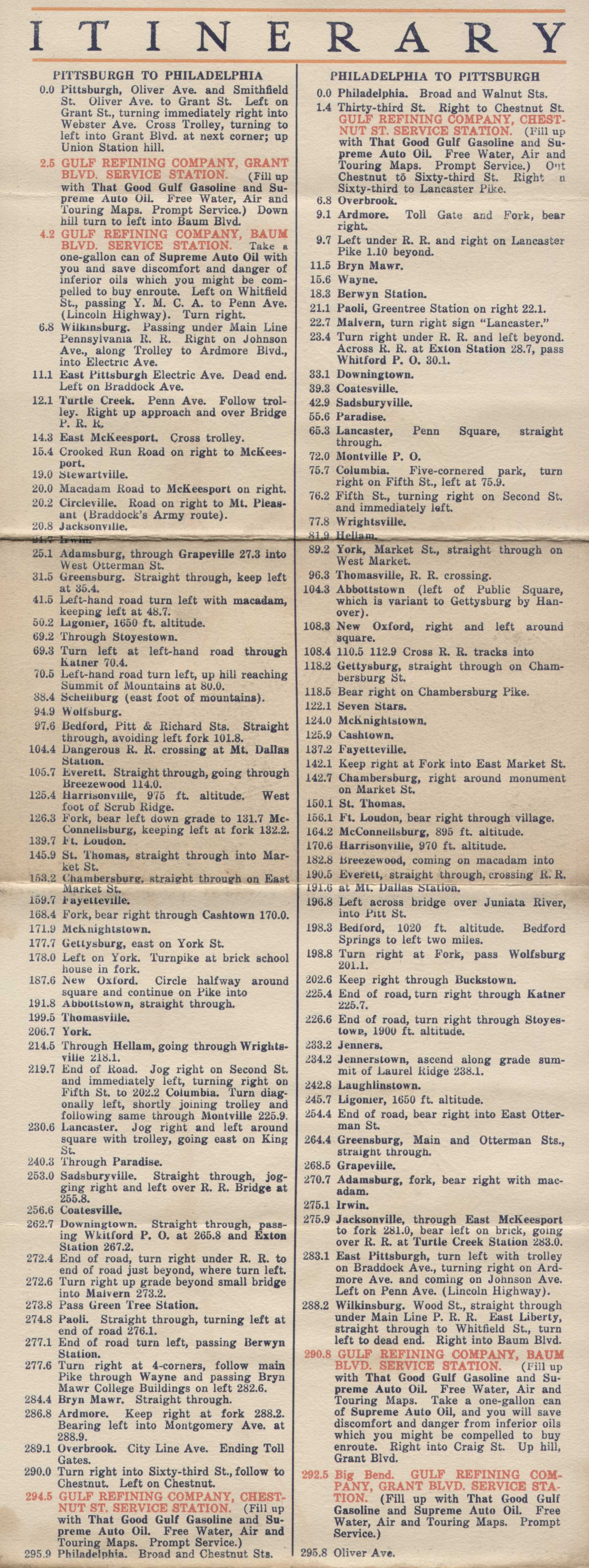
The listings below cover the years up to 1930 and do not include all the Pennsylvania maps from Gulf over this period. However, an illustration is given of what the maps looked like from year-to-year and the different types of maps issued. There were basically three types: state maps, local maps (usually of Pittsburgh or Philadelphia), and trip maps. The trip maps showed a highlighted route between two (or more) cities and were often in the form of a mailer. Both the map cover and the map itself are shown.
| 1913 W. B. AKINS, ALLEGHENY COUNTY. Akins apparently drafted and printed this map himself; no image has (as yet) been obtained. Akins was a Pittsburgh advertising man who sold Gulf on the idea of mailing road maps to potential customers for the new-fangled gas stations they were about to open. Around ten thousand road maps were distributed in the Pittsburgh area. [4] These were plain maps printed on rough paper with a mailer face and paid postage permit. | ||
| 1914 W. B. AKINS, PENNSYLVANIA. No image of this map has (as yet) been obtained. Gulf considered Akins' idea a success and in 1914 four state maps, also including New England, New York, and New Jersey, were prepared and about three hundred thousand copies distributed through the mails and given out at Gulf stations. These also were plain maps printed on rough paper with a mailer face and paid postage permit. | ||
 |
 |
1915.1 AUTOMOBILE BLUE BOOK, PENNSYLVANIA. By 1915 the map demand became so large that business was shifted to the Automobile Blue Book Company, which had been making road maps and guides since 1901. This map has a bright yellow cover with three people in a red car. The middle panel has uncaptioned pictures. The map is copyright 1915 by A.B.B.P. Co., or the Automobile Blue Book Publishing Company. It also has a reference to volume 3 of the 1915 Blue Book for the route numbers shown. Main routes are in red. Size: 11 x 9 inches. |
 |
 |
1915.2 AUTOMOBILE BLUE BOOK. Although not stated on the cover, this is a Pennsylvania map. It has a yellow cover and size similar to the one above, but it is a two-fold map. The cover writing is the same except for the top and bottom blocks. The back cover writing appears the same. The map itself appears identical to the three-fold map above except for some additional text. Main routes are marked in red. This map was not issued separately, but was an insert into the Automobile Blue Book for 1915. Size: 10.5 x 9 inches. |
 |
 |
1915.3 AUTOMOBILE BLUE BOOK, PITTSBURGH-BUFFALO-CLEVELAND. This is a trip map printed in orange and black on cheaper paper than the state map. The same car is used on the cover, but the box is different with different text. The coverage includes eastern Ohio, western Pennsylvania and a small piece of New York. The routes between the cities are highlighted in orange. The pictures in the middle panel are captioned and the back panel has the logo "The Carbon Theory Exploded." The map is copyright 1915 by A.B.B.P. Co. and refers to the 1915 Blue Book for route numbers. This map is slightly smaller than the state map at 11 x 8.5 inches. |
 |
 |
1915.4 PITTSBURGH TO UNIONTOWN ONE DAY TOUR. This is an undated and anonymous map, probably 1915 or 1916. It has a single fold and is not a mailer which may favor the earlier date. Also, only the original Baum Boulevard Gulf station is mentioned. The map covers just one of the four sections with the route description on two sections. Size: 8.5 x 7.5 inches. |
 |
 |
1916.1 AUTOMOBILE BLUE BOOK, PENNSYLVANIA. This map has a yellow cover much like the 1915 state map; the pictures on the middle panel are captioned. There is a 1916 copyright along the left edge and the route number reference to the Blue Book is put on with a stamp. Main routes are shown in red. This is the last appearance of the yellow cover, after this all maps were the cheaper orange and black printings like the 1915 trip map above. This was probably done to save money on printing and paper as the number of autos was increasing fast and maps were likely flying out the door. Also, the orange color was becoming an advertising logo for Gulf. Size: 11 x 9 inches. |
 |
 |
1916.2 AUTOMOBILE BLUE BOOK. Although not stated on the cover, this is a Pennsylvania map. It has a yellow cover and size similar to the one above, but it is a two-fold map. In additon to a two fold design, the cover writing is different; the back cover writing appears the same. There is a 1916 copyright along the bottom from the Automobile Blue Book Pub. Co. Main routes are shown in red. The map itself appears identical to the three-fold map above. Like map 1915.2, this map was not issued separately, but was an insert into the Automobile Blue Book for 1916; which contained another similar insert advertising Atlantic gasoline. Size: 10.5 x 9 inches. |
 |
 |
1916.3 WEEK END TOURS PITTSBURGH TO BEDFORD. The printer of this undated trip map is not identified. The script writing on the map orange dot is similar to the 1916 map, while the cover resembles the 1917 map. This is an early map, probably 1915 or 1916 since Pittsburgh is mentioned as having only two Gulf gas stations, one on Grant Boulevard (i.e. Street) and the first one on Baum Boulevard opened December, 1913. Size: 10 x 8.5 inches. |
 |
 |
1916.4 THE LINCOLN HIGHWAY PITTSBURGH PHILADELPHIA ROUTE MAP AND RUNNING DIRECTIONS ALSO THE PROPOSED WM. PENN HIGHWAY. An anonymous and undated map but believed to date to 1916 or 1917. The William Penn Highway Association was formed in March, 1916, two gas stations are mentioned for Pittsburgh and one for Philadelphia; so, dated 1916 here. This is a long narrow map with multiple folds. On one side is the cover and, rotated ninety degrees, an itinerary. On the other side is the map, most of which is shown here. Size: 6.25 x 19.5 inches. |
 |
 |
1916.5 AUTOMOBILE BLUE BOOK, PENNSYLVANIA. This map is similar to the 1916 Pennsylvania map above, with pictures on the back and the same road map. However, it is a different map using the cheaper printing and paper of later maps. Size: 8.5 x 11 inches. |
 |
 |
1917.1 AUTOMOBILE BLUE BOOK, PENNSYLVANIA. This state map has an orange and black cover like the 1915 trip map above, but with text instead of pictures in the middle panel; probably because text was cheaper to print and better advertising. The rear panel has the logo "The Carbon Theory Exploded" like the 1915 map. The Automobile Blue Book phrase appears on the left of the map but without a copyright date. No route numbers appear on the map, however the William Penn Highway (Route 22), Lincoln Highway (Route 30), and National Road (Route 40) are named. Additional roads from Lewistown to Mt. Union and Huntingdon to Everett have been added to the map. The orange route overlay has been misprinted an inch to the left on this particular specimen; however another identical copy does not show this misprint. Size: 11 x 9 inches. |
 |
 |
1917.2 HALF DAY TOURS, with at bottom PHILADELPHIA, LAMBERTVILLE, TRENTON. No printer is identified for this undated trip mailer map. It is believed to be a 1917 map based on the cover and three gas stations listed for Pittsburgh, with the original Baum Boulevard station shown on the left panel. Size: 8.5 x 11 inches. |
 |
 |
1917.3 PHILADELPHIA-VALLEY FORGE VIA NORRISTOWN AND COLLEGEVILLE with HALF DAY TOUR at bottom. No printer is identified for this mailer. It has a cover like the maps above with 3 gas stations for Pittsburgh and 2 for Philly. Size: 8.5 x 11 inches. |
 |
 |
1917.4 PITTSBURGH TO NIAGARA FALLS VIA ERIE AND BUFFALO, with WEEK END TOUR at bottom. No printer identified and undated. This is believed to be a 1917 map based upon the cover. Also Pittsburgh is mentioned as having three gas stations and Wilkensburg one; Philadelphia is mentioned as having two stations and Atlantic City one. Size: 8.5 x 11 inches. |
 |
 |
1917.5 WEEK END TOUR PHILADELPHIA TO DELAWARE WATER GAP. A mailer map with no printer identified and undated; but believed to be a 1917 map based upon the cover. Also Philadelphia is mentioned as having two stations and Atlantic City one. The map is a 2 x 8 inch strip on the verso with travel directions. Size: 8.5 x 11 inches. |
 |
 |
1917.6 PHILADELPHIA-GETTYSBURG VIA BALTIMORE AND FREDERICK, MD., with WEEK END TOUR at bottom. A mailer map with no printer identified and undated; but believed to be a 1917 map based upon the cover. The map is a 5 x 10 inch strip on the verso with travel directions. The mailer space has a stamped address. Size: 8.5 x 11 inches. |
 |
 |
1917.7 PHILADELPHIA TO NEW YORK RETURNING VIA ASBURY PARK, with WEEK END TOUR at bottom. A mailer map with no printer or date identified; dated 1917 by cover. Also Pittsburgh has four gas stations, Philadelphia has two, and Atlantic City has one. Trip directions surround the map. Size: 8.5 x 11 inches. |
 |
 |
1917.8 HALF DAY TOUR on top; PHILADELPHIA TO WILMINGTON VIA WEST CHESTER at bottom. No printer or date on this mailer tour map with a 1917 cover. There is a one cent stamp and Pittsburgh postage mark but no date. The map covers two-thirds of the verso along with text directions. Philadelphia has two gas stations listed and Atlantic City has one. This copy is printed on heavier paper than usual. Size: 8.5 x 11 inches. |
 |
 |
1918.1 AUTOMOBILE BLUE BOOK, PENNSYLVANIA. The map is identical to the 1917 map above (without the overlay misprint), however the cover changes. The text on the front cover has "free carbon" instead of "carbon" as the last line in the text box, and the logo on the back cover is "Supreme Auto Oil." An oil change recommendation "every 1500 miles" has been added to the middle cover. Size: 11 x 9 inches. |

|
 |
1918.2 THE MOTORISTS' CONVENIENT RECORD OF LUBRICATION, TIRES AND GASOLINE. No printer is identified for this little booklet. It is dated 1918 by the text on the back page. Size: 6.25 x 3.5 inches. |
 |
 |
1918.3 ONE WAY STREETS AND PARKING REGULATIONS PITTSBURGH, PA. This is an undated map of Pittsburgh with no printer identified, and in the form of a mailer. The text has "AFTER SEPT. 1, 1919", so the map dates either 1918 or early 1919. The cover is similar to 1918 maps, so that dating is used here. Five Gulf stations are listed for Pittsburgh, shown on the map, and two for Philadelphia. Size: 11 x 9 inches. |
 |
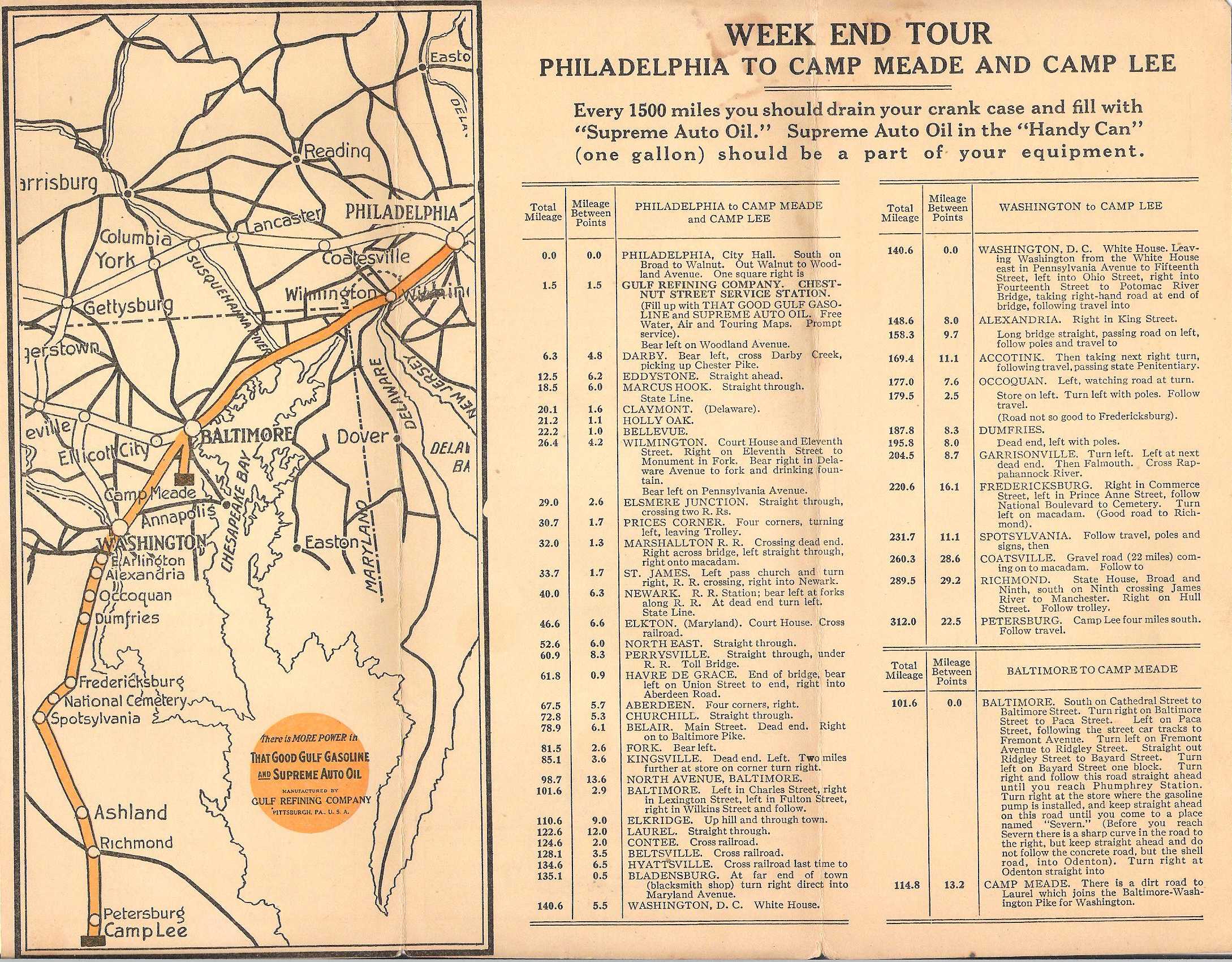 |
1918.4 PHILADELPHIA TO CAMPS MEADE AND LEE at top, NATIONAL CAMP TOUR at bottom. This map can be dated to 1918 from the post mark as well as the cover. The route runs south through Maryland to Camp Meade and on into Virginia to Camp Lee. The map covers only one panel with text directions on the rest. This map was likely issued with the returning troops from WWI in mind. Pittsburgh has four listed gas stations, Philadelphia two, and Atlantic City has one. Size: 8.5 x 11 inches. |
 |
 |
1918.5 PITTSBURGH TO UNIONTOWN VIA GREENSBURG. ONE DAY TOUR at bottom. This undated map has a cover similar to 1918-19 maps. Pittsburgh is listed with four gas stations, Philadelphia with two, and Atlantic City with one; so it is dated circa 1918. There is no printer identified and it is in the form of a mailer. The map shows a route to Greensburg and then south to Uniontown and on to the Summit hotel, with detailed directions. Size: 8.5 x 11 inches. |
 |
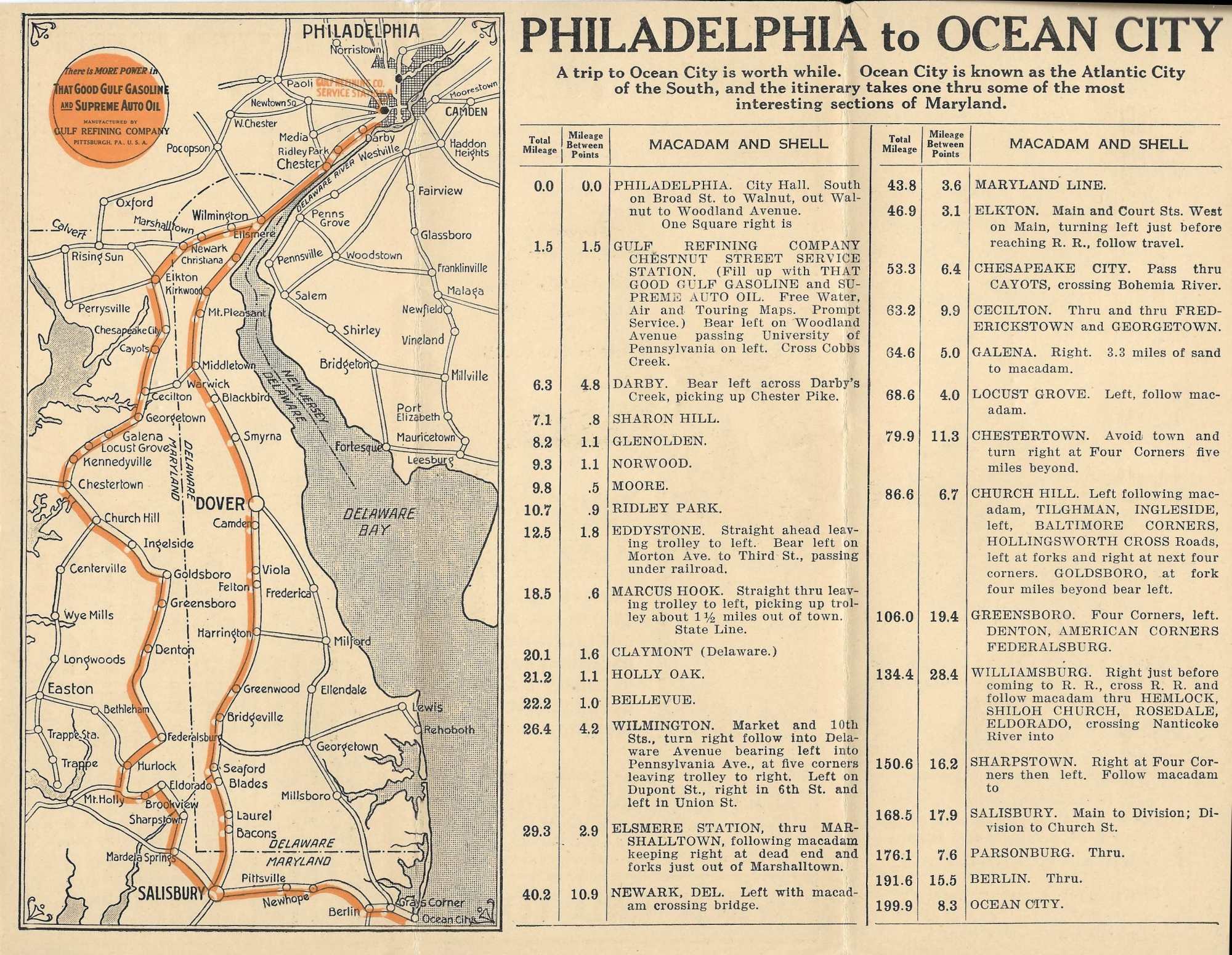 |
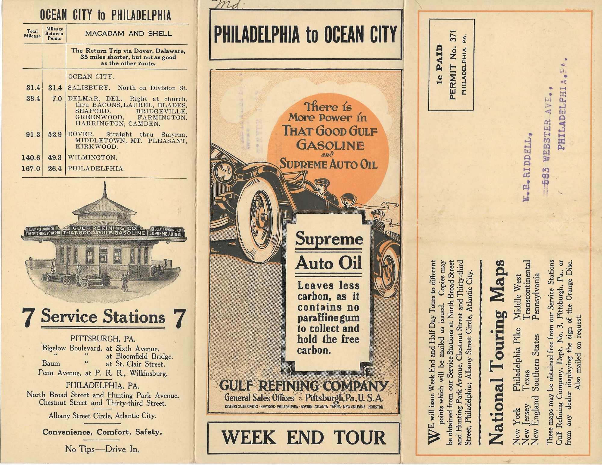
1918.6 PHILADELPHIA TO OCEAN CITY with WEEK END TOUR at bottom. No printer or date identified. This is an early map, probably 1918, as it resembles others dated to 1918. It shows the entire state of Delaware and is more a map of that state than Pennsylvania; but Philly is in the title and shown. Size: 8.5 x 11 inches. |
 |
 |
1919.1 AUTOMOBILE BLUE BOOK, PENNSYLVANIA. This state map utilized the 1916 map plate for some reason. This can be seen by the 1916 date along the left edge and the script text font in the orange circle at bottom left, and also by the missing routes from Lewistown to Mt. Union and from Huntingdon to Everett which were present on the 1917 and 1918 maps. However, the cover has changes. The box on the front cover now is outlined in closely spaced angled lines rather than dots, and the middle panel has different text. Size: 11 x 9 inches. |
 |
 |
1919.2 PITTSBURGH TO CLAIRTON VIA DUQUESNE HALF DAY TOUR. This is an undated map with no printer identified and in the form of a mailer. It has a cover similar to the 1919 map above, so that dating is used here. Five stations are listed for Pittsburgh with three shown on the map. Detail driving instructions are given along with the map. Size: 11 x 9 inches. |
 |
 |
1919.3 TO GETTYSBURG AND BALTIMORE. An undated map with no printer identified, and in the form of a mailer. It has a cover similar to the other 1919 maps, with 5 gas stations in Pittsburgh and 3 listed for Philadelphia. The trip marked out is a round trip from Philadelphia. Size: 11 x 8.5 inches. |
 |
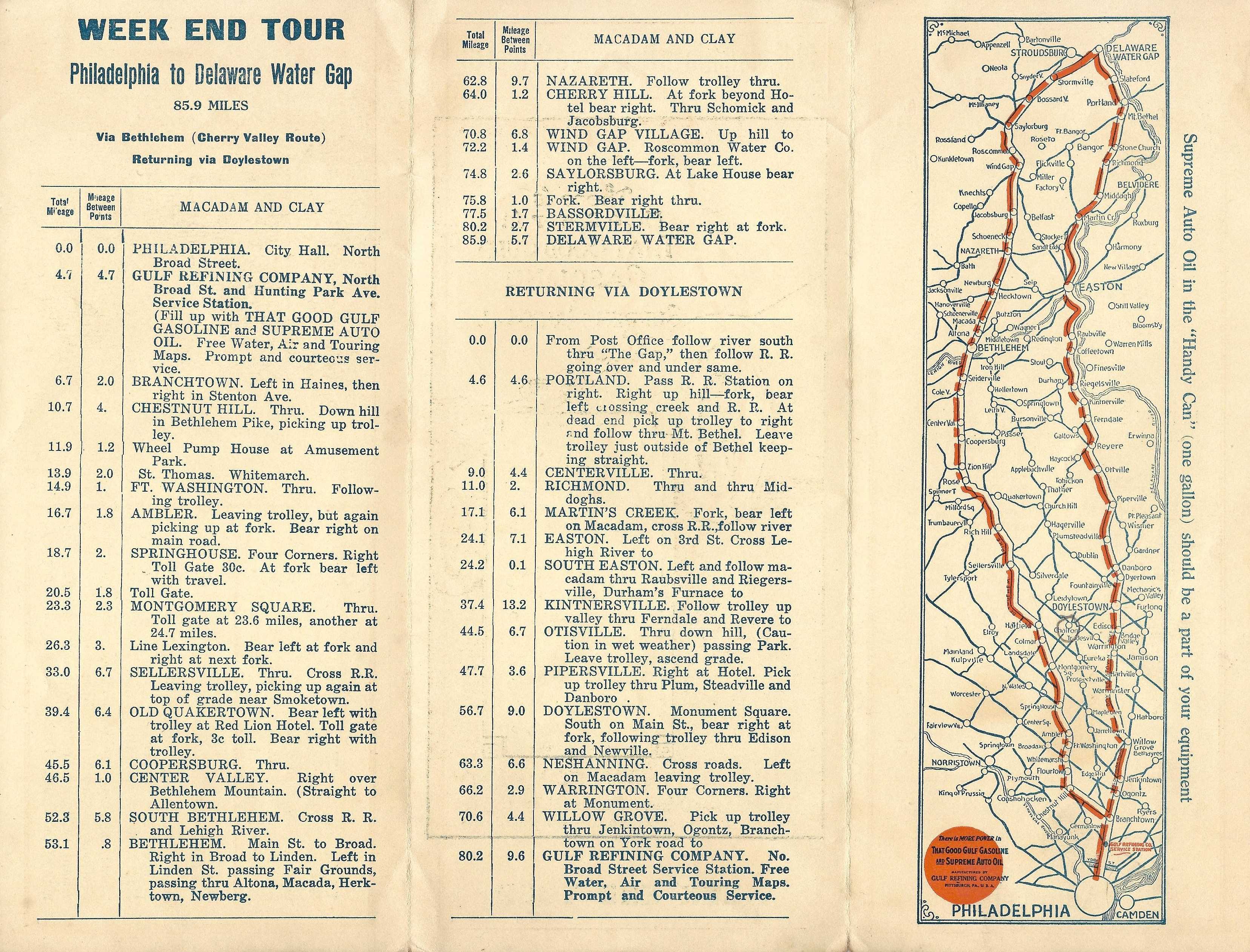 |
1919.4 PHILADELPHIA TO DELAWARE WATER GAP. An undated map with no printer identified, and in the form of a mailer. It has a cover similar to the other 1919 maps, with 5 gas stations in Pittsburgh and 2 listed for Philadelphia, one for Atlantic City. The trip marked out is a round trip from Philadelphia, similar to the 1917 map above but later. Size: 11 x 8.5 inches. |
 |
 |
1920.1 AUTOMOBILE BLUE BOOK, PENNSYLVANIA. The 1916 map plate is again used, but the missing routes mentioned above have now been re-added. The back cover now reads "Auto Oil Supreme" instead of "Supreme Auto Oil." There are also some type face changes and the map is just slightly smaller. Size: 11 x 8.5 inches. |
 |
 |
1920.2 THE TOUR DE LUXE PENNSYLVANIA AND MARYLAND. At bottom the title continues PHILADELPHIA, PITTSBURGH WASHINGTON, BALTIMORE. The printer is not identified. This is a four panel map with route directions on the cover side and a map on the verso. Three panels are shown here. From the cover and other features it is either a 1919 or 1920 map. Size: 14 x 8.5 inches. |
 |
 |
1920.3 THE LINCOLN HIGHWAY PITTSBURGH-PHILADELPHIA-NEW YORK. This is an undated mailer map with no printer identified. It appears to date either 1919 or 1920; five gas stations are mentioned for Pittsburgh. Although the cover mentions only the Lincoln Highway, routing along the William Penn Highway is also highlighted. This is a three panel map with the map across the top third of the back with route instructions below. Size: 8.5 x 11 inches. |
 |
 |
1921.1 AUTOMOBILE BLUE BOOK, PENNSYLVANIA. The 1916 map plate is again used, however the orange circle of text at bottom left has changed. There is a new middle panel of text and the oil change recommendation has moved to the end panel and now reads "every 1000 miles" instead of "every 1500 miles." This is the last Automobile Blue Book map issued. Like the 1920 map, this one is also slightly smaller. Size: 11 x 8.5 inches. |
 |
 |
1921.2 AUTOMOBILE BLUE BOOK, PENNSYLVANIA. This map is a printing variation on the map above. Here, the oil change recommendation has also been printed on the bottom of the front panel. The map is identical to the one above. Size: 11 x 8.5 inches. |
 |
 |
1921.3 PITTSBURGH--WASHINGTON BEALLSVILLE. This three panel trip map has no identified printer. The mailer face has the code "612130" dating it to 1921. The map portion is 7.5 x 5 inches with route directions alongside. Pittsburgh has six gas stations listed and Philadelphia has two. Size: 11 x 8.5 inches. |
 |
 |
1922.1 RAND MCNALLY, BLAZED TRAILS IN PENNSYLVANIA. In 1922 Gulf moved its map business to Rand McNally who had been publishing their popular Official Auto Trails maps since 1917. The map design completely changes. The folding pattern is different, the cover is now the middle panel; the left panel has new text and the right panel lists the Rand McNally Trail Markings. The size increases to 12 x 9 inches. Although the map layout looks similar to previous maps, it is a different map with milage circles centered on Pittsburgh over-printed in orange. |
 |
 |
1922.2 RAND MCNALLY, BLAZED TRAILS IN PENNSYLVANIA. This map is identical to the one above but printed in blue rather than black ink. It is believed to be a later map since subsequent maps were printed in blue. Size: 12 x 9 inches. |
 |
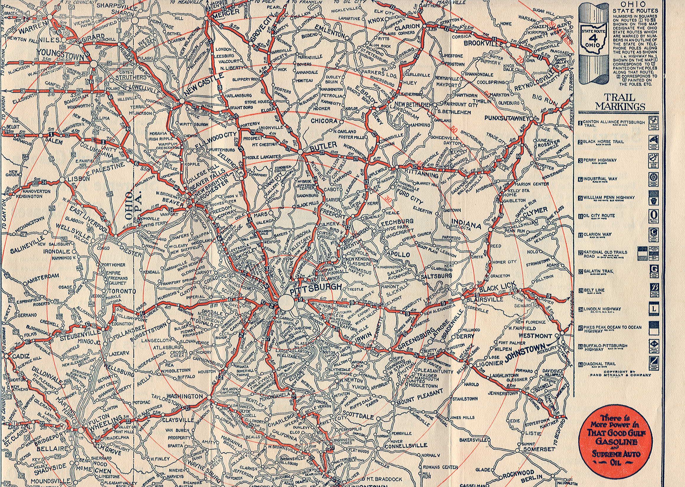 |
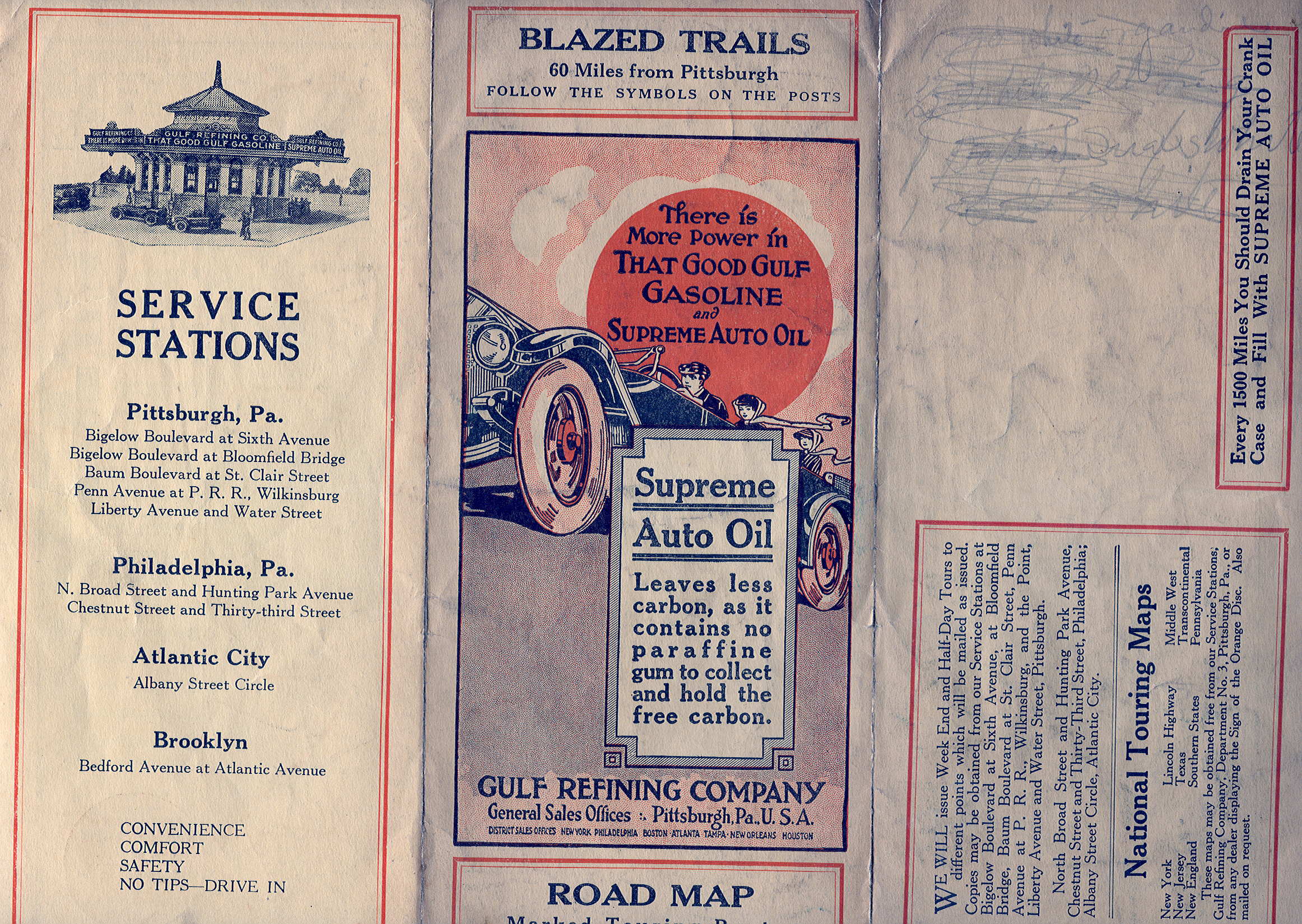
1922.3 RAND MCNALLY, BLAZED TRAILS PITTSBURGH AND VICINITY. The Pittsburgh region is shown east to Johnstown, south to Uniontown, west to Youngstown, and north to Mercer on this local map. The left and right panels are switched relative to the state map and the left panel has a list of gas station locations. The trail markings are placed on the right side of the map panel. The map is printed in black. Size: 12 x 9 inches. |
 |
 |
1922.4 RAND MCNALLY, BLAZED TRAILS 60 MILES FROM PHILADELPHIA. This local map dates either 1922 or 1923, probably 1922 based upon the number of gas stations listed for the cities. It is identical to the similarly named 1923 map below except for the stations listed on the back panel. The trail markings are placed on the top of the map panel. This particular copy is in poor condition. Size: 12 x 9 inches. |
 |
 |
1922.5 RAND MCNALLY, BLAZED TRAILS 60 MILES FROM PITTSBURGH. This local map is the Pittsburgh companion to the Philadelphia map above, although it is not identical in layout. It is similar to the "VICINITY" map above. It dates either 1922 or 1923, but probably 1922 based upon the number of gas stations listed for the cities. Size: 12 x 9 inches. |
 |
 |
1922.6 PHILADELPHIA TO WERNERSVILLE. This is a trip map from an unidentified printer. It dates to 1922 from a note "6-1-22-75," and also matches the 1922 maps above. It is printed in blue. This map is smaller than the other 1922 maps at 11 x 8.5 inches. |
 |
 |
1922.7 PITTSBURGH TO CLEVELAND. This is another trip map from an unidentified printer. It dates to 1922 from the note "6-1-22-75," and also matches the 1922 maps above. The map is about 5.5 x 7 inches, the rest of the area is filled with directions. Pittsburgh is noted as having six gas stations. 11 x 8.5 inches. |
 |
 |
1922.8 RAND MCNALLY, BLAZED TRAILS PHILADELPHIA AND VICINITY. The Philadelphia region is shown west to Lancaster and with most of New Jersey. One fold has a map of downtown. Dated to 1922 based on the cover and the list of gas stations, with two in Philadelphia. This map is very similar to the one above titled 60 MILES FROM PHILADELPHIA. Size: 12 x 9 inches. |
 |
 |
1923.1 RAND MCNALLY, BLAZED TRAILS IN PENNSYLVANIA. The text on the left panel changes and the trail marking list on the right panel is different. Also, it is recommended that oil be changed "every 500 to 1000 miles." The map appears identical to 1922 but assigned route numbers change and a stamp on road types appears beside the orange disc. Size: 12 x 9 inches. |
 |
 |
1923.2 THE TOUR DE LUXE PENNSYLVANIA AND MARYLAND. This is a four fold trip map from an unidentified printer. The cover matches the "every 500 to 1000 miles" on the 1923 map above although the front panel is on the right. The map and trip directions cover all four panels, only three are shown here. Size: 14 x 8.5 inches. |
 |
 |
1923.3 PHILADELPHIA TO ATLANTIC CITY & CAPE MAY. The printer for this mailer map is not identified. It can be dated from the note: 6-1-23-75. On the mailer face is a list of other available touring maps. Size: 11 x 8.5 inches. |
 |
 |
1923.4 RAND MCNALLY, BLAZED TRAILS PHILADELPHIA AND VICINITY. This map dates either 1922 or 1923, probably 1923 based upon the number of gas stations listed for the cities. It has concentric circles around Philadelphia and is similar to the 1922 "60 MILES" map above. Size: 12 x 9 inches. |
 |
 |
1923.5 PITTSBURGH TO CLEVELAND. No printer is identified for this anonymous map dated based upon the cover and 10 gas stations listed for Pittsburgh. There are three panels with the map covering the upper two-thirds of two panels and surrounded by route directions. Two different routes are shown and described. Size: 11 x 8.5 inches. |
 |
 |
1923.6 RAND MCNALLY, BLAZED TRAILS 60 MILES FROM PHILADELPHIA. This local map is printed in blue and dates either late 1922 or 1923. It is identical to the similarly titled 1922 map above except for additional gas stations listed on the back cover. So, assuming these maps were updated annually, it is dated 1923 here. The trail markings are placed on the top of the map panel. Size: 12 x 9 inches. |
 |
 |
1924.1 RAND MCNALLY, BLAZED TRAILS IN PENNSYLVANIA. The cover panel changes to just one woman riding in the car and a crossroads sign is on the left. The map plate is different with a new orange Gulf disc. This map is labeled Map No. 4. Also, the Allegheny National Forest, created in 1923, is identified.Size: 12 x 9 inches. |
 |
 |
1924.2 RAND MCNALLY, BLAZED TRAILS OF PITTSBURGH AND VICINITY. The cover on this local map is the same as the state map but the right panel has a list of station locations instead of trail markings, which are placed inside on the map. State routes are shown for Ohio and West Virginia but not for Pennsylvania. This map is labeled Map No. 8. In later years, the Pittsburgh map became No. 7. Size: 12 x 9 inches. |
 |
 |
1924.3 RAND MCNALLY, BLAZED TRAILS OF PHILADELPHIA AND VICINITY. This map is similar to the Pittsburgh one above. About two-thirds of New Jersey is also included. This map is labeled Map No. 7. In later years, the Philadelphia map became No. 6. Size: 12 x 9 inches. |
 |
 |
1924.4 C. R. MOORE CO. PGH., PHILADELPHIA TO VALLEY FORGE VIA NORRISTOWN AND COLLEGEVILLE. This mailer map can be dated from the note: 6-1-24-75. This is the only mailer trip map seen with the printer (or engraver) identified; the name in tiny letters is at the bottom right of the cover. Size: 11.5 x 9 inches. |
 |
 |
1924.5 PHILADELPHIA TO LONG BRANCH, ASBURY PARK AND SHORE RESORTS. No printer is identified for this three panel trip mailer; it can be dated from the note: 7-1-24-75. Size: 9 x 11.5 inches. |
 |
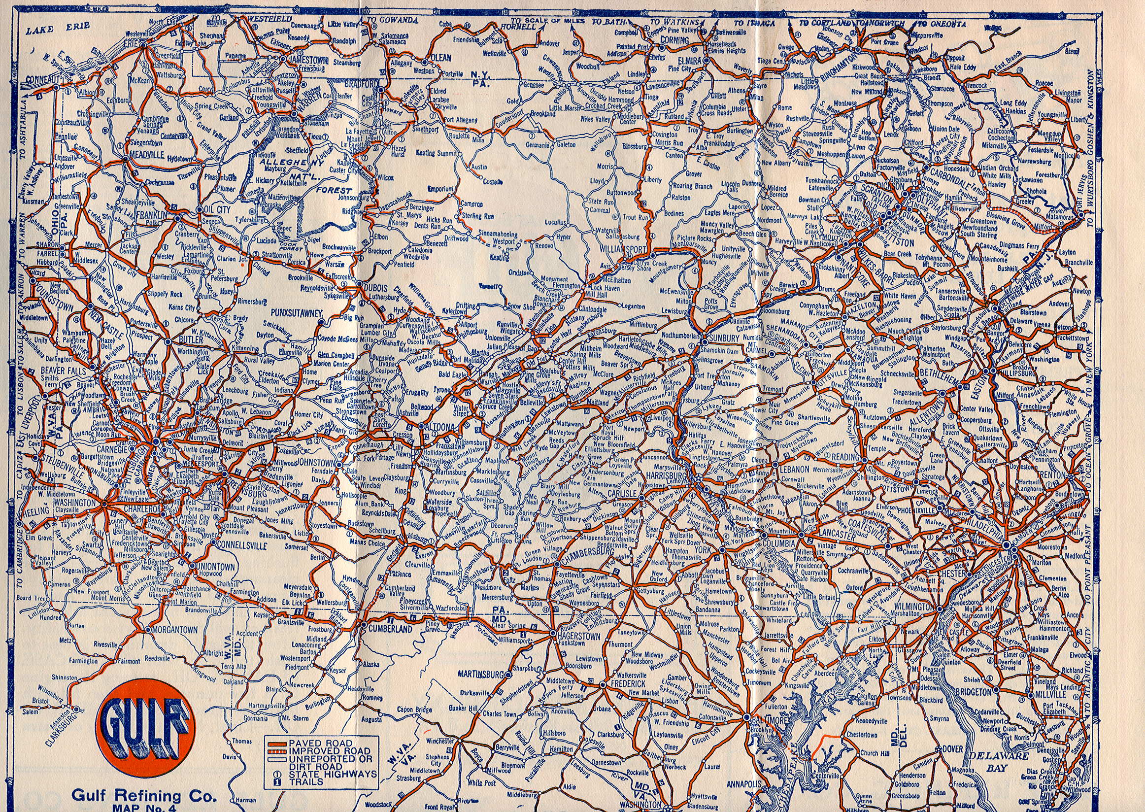 |
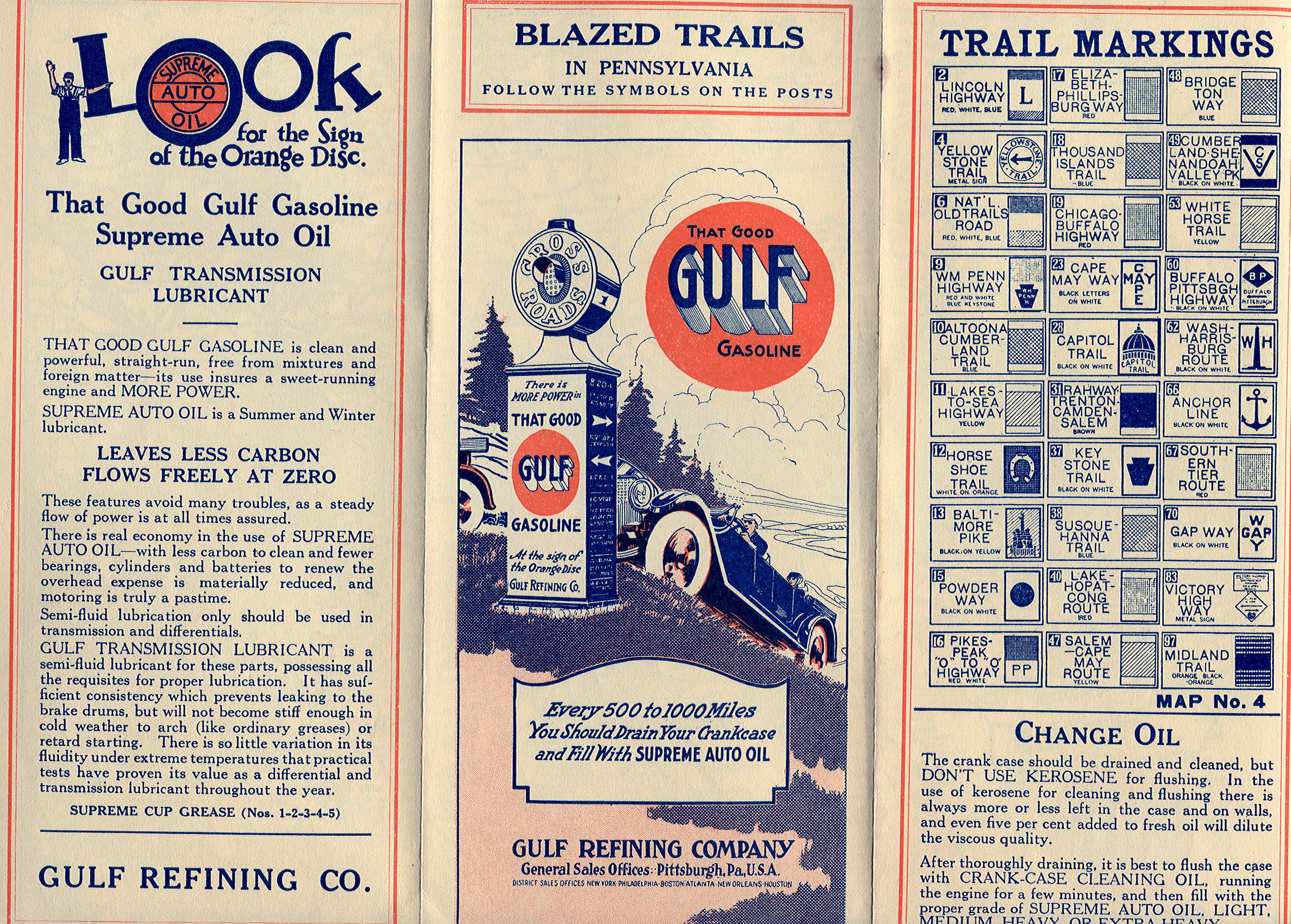
1925.1 RAND MCNALLY, BLAZED TRAILS IN PENNSYLVANIA. The cover changes; there are now two women in the car and the crossroads marker is gone. The box with "every 500 to 1000 miles" now has an orange trim. The map is the same as for 1924 but has a new edge trim and road descriptions are printed, instead of stamped, at lower left. Some routes previously shown as "improved" are now shown as "paved." This is labeled Map No. 4. Size: 12 x 9 inches. |
 |
 |
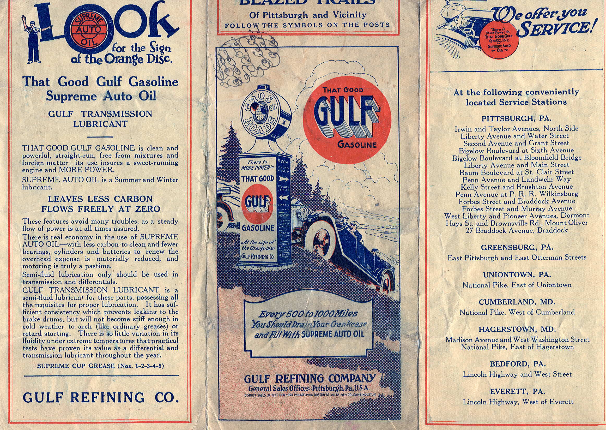
1925.2 RAND MCNALLY, BLAZED TRAILS OF PITTSBURGH AND VICINITY. The cover and left panel of this local map are the same as the state map, the right panel has text instead of trail markings. State highway markers for Pennsylvania are now identified on the map. This is labeled Map No. 8. Size: 12 x 9 inches. |
 |
 |
1925.3 PITTSBURGH-ERIE-BUFFALO NIAGARA FALLS. The printer of this trip map is not identified, but the map can be dated from the note "8-1-25-175M." The cover is the same as the other 1925 maps, the right panel is a mailer. Detailed driving instructions are given on how to get to Niagara Falls. This map is slighly smaller at 11.5 x 9 inches. |
 |
 |
1925.4 PARKING REGULATIONS CITY OF PITTSBURGH. The printer of this mailer local map is not identified; it can be dated from the note "6-1-25-100M." This is a four, rather than three, panel map. The extra two panel sides contain Pittsburgh parking regulations. The map of downtown Pittsburgh covers three panels. Size: 16 x 9 inches. |
 |
 |
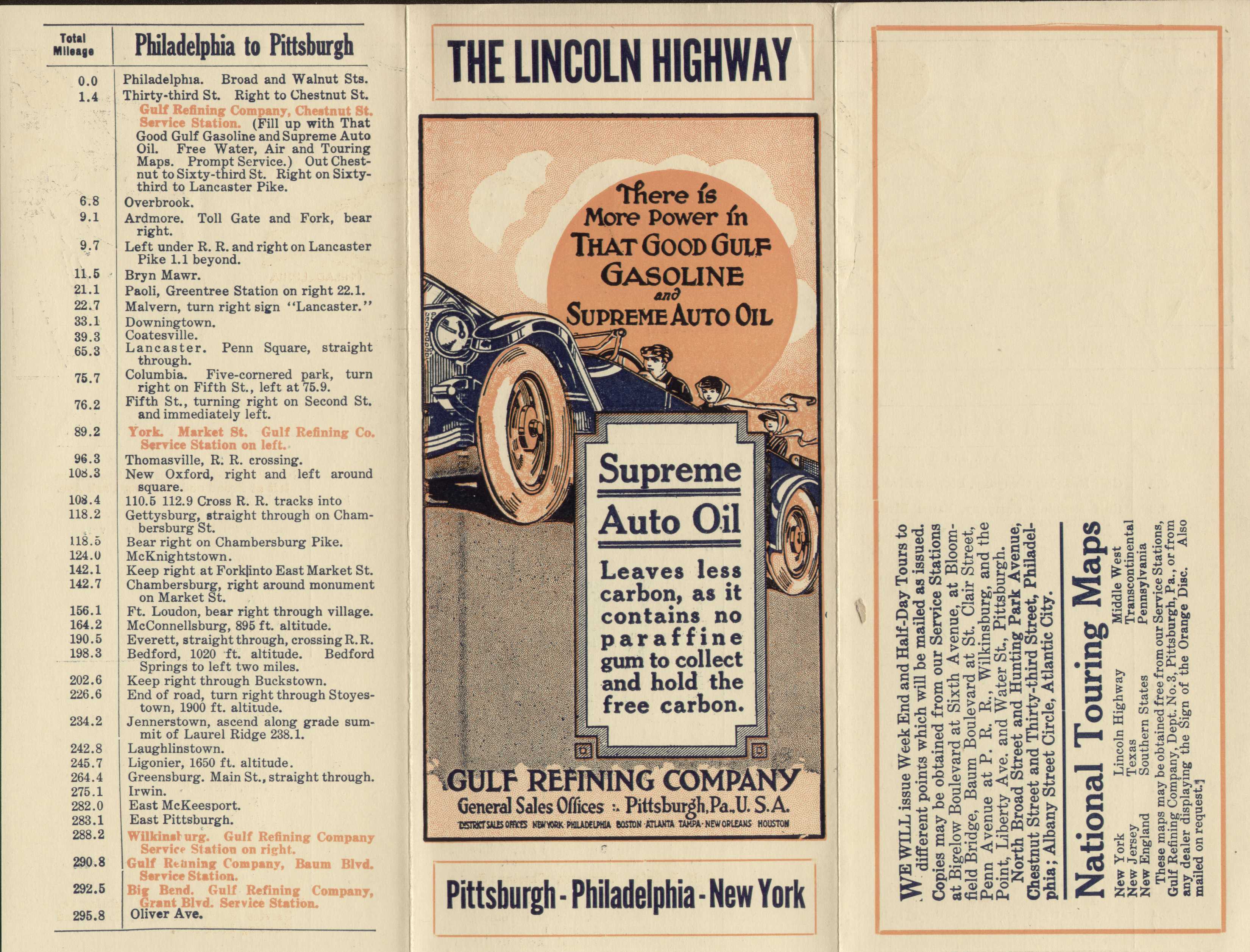
1925.5 THE LINCOLN HIGHWAY PITTSBURGH-PHILADELPHIA-NEW YORK. The printer of this mailer trip map is not identified; it can be dated from the note "7-1-25-300M." The cover is the same as the other 1925 maps. The left panel has driving instructions and the right panel is a mailer. The map inside covers only the top third and the rest below is driving instructions. This map is smaller at 11 x 9 inches. An otherwise identical version of this map was seen where the back panel is an ad rather than a mailer. |
 |
 |
1925.6 PHILADELPHIA TO SANATOGO PARK -AND- POTTSTOWN. The printer of this mailer trip map is not identified; it can be dated from the note "8-1-25-175M." The cover is the same as the other 1925 maps. The left panel has text and the right panel is a mailer. The map inside covers only the top third and the rest below is driving instructions for a trip to and from Pottstown. The size is 11 x 9.5 inches. |
 |
 |
1925.7 PHILADELPHIA TO GETTYSBURG RETURNING VIA WASHINGTON & BALTIMORE. A mailer tour map dated from the note 6-1-25-175M.' No printer identified, the map covers the top of two panels surrounded by driving directions. Size: 9 x 11.5 inches. |
 |
 |
1925.8 PHILADELPHIA TO MAUCH CHUNK RETURNING VIA POTTSVILLE AND READING. A mailer trip map dated from the note 9-1-25-175M.' No printer is identified and the map covers only one panel with driving directions on the rest. Size: 9 x 11.5 inches. |
 |
 |
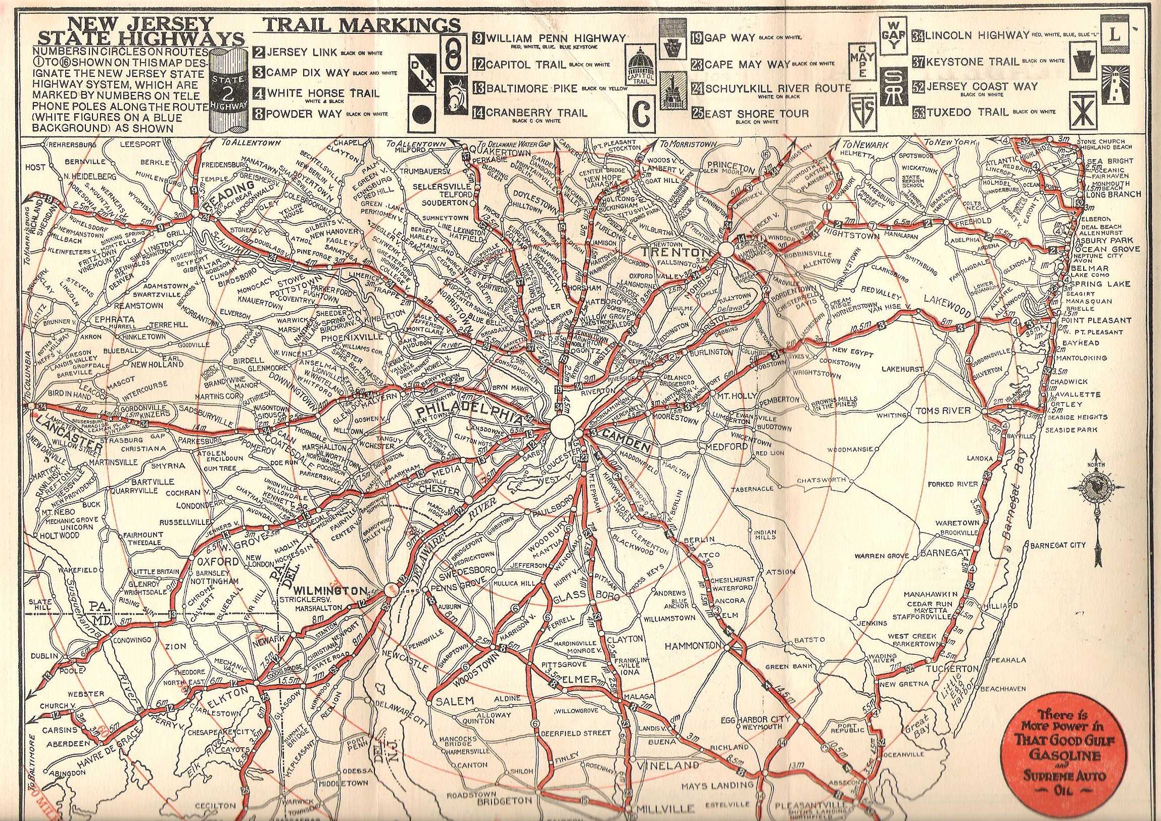
1925.9 RAND MCNALLY, BLAZED TRAILS OF PHILADELPHIA AND VICINITY. This is believed to be the 1925 map based on the cover. Roads are identified with trail markings and old state route numbers. The Philadelphia region is shown west to Lancaster and with most of New Jersey. Size: 9 x 11.5 inches. |
 |
 |
1925.10 PHILADELPHIA TO ASBURY PARK AND SHORE RESORTS. A mailer trip map dated from the note 7-1-25-175M.' No printer is identified. The map covers all three panels across the top with driving directions below. Size: 9 x 11.5 inches. |
 |
 |
1926.1 RAND MCNALLY, MAP NO.
4 AUTOMOBILE ROADS IN PENNSYLVANIA. Although the cover
remains the same as the 1925 map, the title and
everything else changes. The big change is the size of
the map which doubles to 18 x 12 inches, shown in west
and east
sections. Routes are now marked
with old state route numbers. All of New Jersey and a lot
of Maryland and Delaware are included. The extra room on
the cover side is filled with maps of Philadelphia and
Pittsburgh. Gulf's coverage of the United States in maps gradually increased over the years, and in 1926 numbers began appearing in the title. From 1926 on, the number order was as follows:1) Northern New England, 2) Southern New England, 3) New York, 4) Pennsylvania, 5) New Jersey, 6) Philadelphia & Vicinity, 7) Pittsburgh & Vicinity, 8) Louisville & Vicinity, 9) Ohio, 10) Delaware, Maryland, Virginia & West Virginia, 11) Tennessee & Kentucky, 12) North & South Carolina & Northern Georgia,13) Florida & Southern Georgia, 14) Georgia, 15) Alabama & Mississippi, 16) Louisiana & Arkansas, 17) Texas, 18) Middle West, 19) United States, 20) Ontario, 21) Long Island & Vicinity. |
 |
 |
1926.2 RAND MCNALLY, MAP NO. 7 AUTOMOBILE ROADS OF PITTSBURGH AND VICINITY. The cover for this local map is the same as the state map except for the title; the size is also the same, 18 x 12 inches. The Pittsburgh region is shown in west and east sections. The cover side includes maps of Wheeling, Youngstown, and Washington (Pennsylvania). |
 |
 |
1926.3 RAND MCNALLY, MAP NO. 6 AUTOMOBILE ROADS OF PHILADELPHIA AND VICINITY. This map is similar to the Pittsburgh map above, the size is also the same, 18 x 12 inches. A map of New York is included. Only the west side of the regional map is shown here. |
 |
 |
1926.4 THE TOUR DE LUXE, PITTSBURGH - WASHINGTON - PHILADELPHIA. Hard to say what is deluxe about this trip, here Washington DC is meant. No printer is identified, although the cover panel is the same as the other Rand McNally 1926 maps except for the title and the fact that it is on the right. This is a smaller three panel map 12 x 9 inches, and most of the space is filled with detailed driving directions with the map itself taking up only the top half of three panels. |
 |
 |
1926.5 CITY OF PHILADELPHIA ROAD MAP AND PLACES OF INTEREST. The printer of this map is not identified. Based on the size and cover, this is a 1926 map. Only the central portion of the 18 x 12 inch regional map is shown here. The location of Gulf stations in the city is given. |
 |
 |
1926.6 PHILADELPHIA TO HARRISBURG RETURNING VIA LANCASTER AND COATESVILLE. The printer of this trip map is not identified, it can be dated from the note '9-1-26-150M.' The logo printing on the left panel is gone so all the trip directions can be printed. Size: 11.5 x 9 inches. |
 |
 |
1926.7 PHILADELPHIA TO POINT PLEASANT RETURNING VIA NEW HOPE AND MORRISVILLE. The printer of this trip map is not identified, it can be dated from the note '8-1-26-150M.' It is similar to the trip map above. Size: 11.5 x 9 inches. |
 |
 |
1926.8 PHILADELPHIA TO CAPE MAY. The printer of this trip map is not identified, it can be dated from the note '7-1-26-150M.' It is similar to other trip maps above. Size: 11.5 x 9 inches. |
 |
 |
1926.9 PHILADELPHIA TO VALLEY FORGE VIA NORRISTOWN AND COLLEGEVILLE. The printer of this trip map is not identified, it can be dated from the note '6-1-26-150M.' It is similar to the 1924 trip map above with the same title. Size: 11.5 x 9 inches. |
 |
 |
1926.10 PITTSBURGH TO ERIE-BUFFALO-NIAGARA FALLS. A three panel mailer map with route directions and map on the verso. No identified printer, it can be dated from the cover and note: 7-1-26. There is a list of other available touring maps on the mailer face. Size: 11.5 x 9 inches. |
 |
 |
1927.1 H. M. GOUSHA, MAP NO. 4 AUTOMOBILE ROADS IN PENNSYLVANIA. This map is coded 'A' making it the first Gousha road map of Pennsylvania. Harry Gousha was a Rand McNally salesman who founded his own map company in 1926-27. Gulf was among his first customers. The same title and format as in the previous Rand McNally maps was used, however the car on the cover becomes a convertible coupe. The roads are marked by both old state and modern US route numbers. The maps are similar in layout but they are different maps. The Pennsylvania map is shown here in west and east sections. Size: 18 x 12 inches. |
 |
 |
1927.2 H. M. GOUSHA, MAP NO. 7 AUTOMOBILE ROADS OF PITTSBURGH AND VICINITY. The cover is the same as the state map. The "vicinity" map is shown here in west and east sections. Size: 18 x 12 inches. |
 |
 |
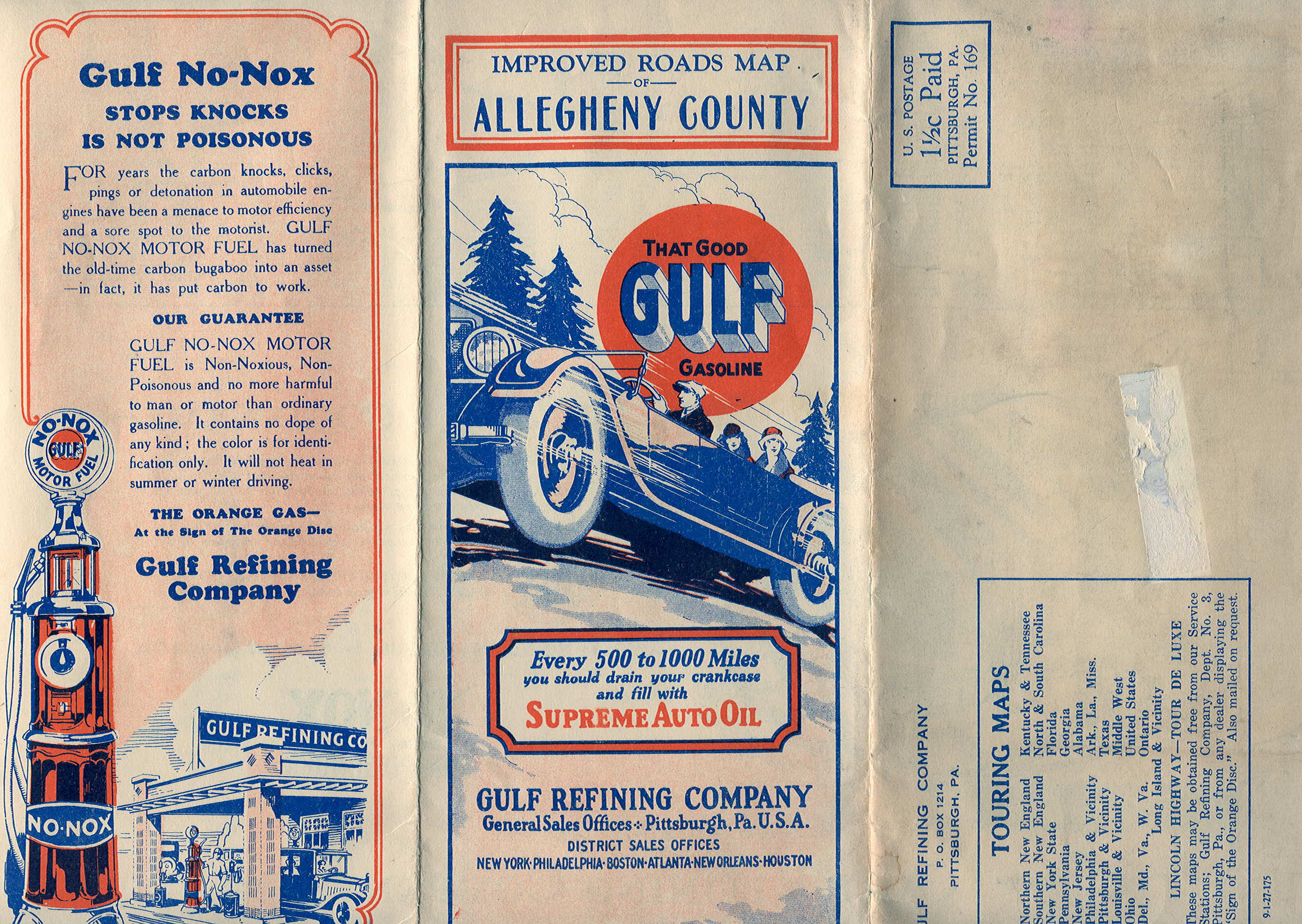
1927.3 LEWIS PUBLISHING CO., IMPROVED ROADS MAP OF ALLEGHENY COUNTY. This local mailer map can be dated from the note "9-1-27-175," however the cover matches the 1926 maps with the right panel being the mailer face. This was a special local map, Lewis Publishing Company was located in Pittsburgh, the county seat of Allegheny County. A large ad occupies three panels on the cover side, and the county is shown in north and south sections on the map side, with the Lewis stamp at upper right. Size: 18 x 12 inches. |
 |
 |
1927.4 PITTSBURGH TO ERIE-BUFFALO--NIAGARA FALLS. The printer of this trip map is not identified, it can be dated from the note '7-1-27-150M.' It also uses the 1927 cover as the maps above. Size: 11.5 x 9 inches. |
 |
 |
1927.5 PITTSBURGH TO JOHNSTOWN VIA WM. PENN HIGHWAY RETURNING VIA LINCOLN HIGHWAY. The printer of this trip map is not identified, it can be dated from the note '6-1-27,' and it also uses the 1927 cover. Like the trip map above, this one is a smaller size, 11.5 x 9 inches. |
 |
 |
1927.6 PHILADELPHIA TO GETTYSBURG-WASHINGTON-WILMINGTON. The printer of this trip map is not identified; it can be dated from the note '9-1-27-150-M,' and is similar to the other trip maps with the size of 11.5 x 9 inches. |
 |
 |
1927.7 PHILADELPHIA TO SOUTH AMBOY RETURNING VIA ASBURY PARK AND LAKEWOOD, N.J. A mailer trip map dated from the note 7-1-27-150-M.' No printer is identified. The map covers the top half of the verso with driving directions underneath. Most of the trip is through New Jersey. Size: 9 x 11.5 inches. |
 |
 |
1927.8 H. M. GOUSHA, MAP NO. 6 AUTOMOBILE ROADS OF PHILADELPHIA AND VICINITY. This is similar to the Pittsburgh map above. The "vicinity" map is shown here. Size: 18 x 12 inches. |
 |
 |
1927.9 PITTSBURGH TO COLUMBUS VIA WHEELING, CAMBRIDGE & ZANESVILLE. No printer identified, dated from a note '7-1-27, also matches the 1927 cover. The map covers a third of the page with route directions underneath. Size: 9 x 11.5 inches. |
 |
 |
1928.1 H. M. GOUSHA, MAP NO. 4 AUTOMOBILE ROADS IN PENNSYLVANIA. A different red coupe is on the cover and has only a single occupant, however the format is the same as the 1927 map. This map is coded 'B', the second Gousha Pennsylvania road map. Pennsylvania is shown here in west and east sections. Size: 18 x 12 inches. |
 |
 |
1928.2 H. M. GOUSHA, MAP NO. 6 AUTOMOBILE ROADS OF PHILADELPHIA AND VICINITY. Philadelphia and New York maps are opposite the cover; the Philly map is the same as the one on the state map above. The large Philadelphia vicinity map on the verso is shown here in west and east sections. It includes almost all of New Jersey. Size: 18 x 12 inches. |
 |
 |
1928.3 PHILADELPHIA TO ASBURY PARK, N. J. AND SEASHORE RESORTS VIA. RAHWAY. This mailer map, with no identified printer, can be dated from the cover and the note:8-1-28. Size: 11.5 x 9 inches. |
 |
 |
1928.4 PHILADELPHIA TO VALLEY FORGE, PA. VIA NORRISTOWN, AND RETURNING VIA ARDMORE, PA. This mailer map, with no identified printer, can be dated from the cover and the note:7-1-28. Size: 11.5 x 9 inches. |
 |
 |
1928.5 PITTSBURGH TO ERIE-BUFFALO-NIAGARA FALLS. A three panel mailer map with route directions and map on the verso. No identified printer, it can be dated from the cover and note: 6-1-28. There is a list of other available touring maps on the mailer face. Note the lubrication chart and the many old cars listed and no longer made. Size: 11.5 x 9 inches. |
 |
 |
1928.6 H. M. GOUSHA, MAP NO. 7 AUTOMOBILE ROADS PITTSBURGH AND VICINITY. The cover is the same as the state map and this one carries the "B" Gousha code for a 1928 map. The 9 x 12 inch Pittsburgh map is shown at left. The 12 x 18 inch "vicinity" map covers most of western Pennsylvania and a good chunk of Ohio. A portion of it is shown here . The cover has been marked by writing around the edge on this copy. Size: 18 x 12 inches. |
 |
 |
1928.7 PHILADELPHIA TO HARRISBURG VIA READING RETURN VIA LANCASTER. This is a three panel trip map with no printer identified. The map is small, covering only the top third of two panels, with the remaining area trip directions. Size: 9 x 11.5 inches. |
 |
 |
1929.1 H. M. GOUSHA, MAP NO. 4 1929 AUTOMOBILE ROADS IN PENNSYLVANIA. The map doubles in size and is now 24 x 18 inches. Larger maps of Philadelphia and Pittsburgh are used and only the Pittsburgh map is shown here at left. Only the title section of the large Pennsylvania map, the southwest , is shown here . |
 |
 |
1929.2 H. M. GOUSHA, NO. 7 1929 AUTOMOBILE ROADS PITTSBURGH AND VICINITY. This local map remains the same size, 18 x 12 inches, as the 1928 map, and the Pittsburgh vicinity is shown here in west and east sections. |
 |
 |
1929.3 WASHINGTON, D. C. TO HARRISBURG, PA. VIA CUMBERLAND, MD. AND CHAMBERSBURG, PA. RETURNING VIA GETTYSBURG, PA. AND FREDERICK, MD. The printer of this trip map is not identified, it can be dated from the note '9-1-29,' and it also uses the 1929 cover. 11.5 x 9 inches. |
 |
 |
1929.4 H. M. GOUSHA, NO. 6 1929 AUTOMOBILE ROADS OF PHILADELPHIA AND VICINITY. This map is dated on the cover. One side has a 'vicinity map' shown at left, and the verso, besides the cover, has a smaller city map and one of New York City. 12 x 18 inches. |
 |
 |
1929.5 PITTSBURGH, PA. TO PHILADELPHIA, PA. This is a three panel mailer map with the address sticker still attached. No printer is identified. It can be dated from the note 8-1-29 on the back. The indicated route follows US 30. 9 x 11.5 inches. |
 |
 |
1929.6 PITTSBURGH TO CLEVELAND. This is a three panel mailer map with the address sticker still attached. No printer is identified. It can be dated from the cover. One route shown is Route 8 north to Butler and then Route 422 to Cleveland. A second more complicated route is also shown. This map is small, just covering a third of two panels, with most of the space devoted to the complicated route description. 9 x 11.5 inches. |
 |
 |
1929.7 PHILADELPHIA TO GETTYSBURG VIA BALTIMORE RETURN VIA HARRISBURG. Dated from a note on the back 8-1-29, also matches the 1929 cover. No printer is identified. The map is about 4 x 11 inches, the rest is route directions. 9 x 11.5 inches. |
 |
 |
1929.8 H.M. GOUSHA, AUTOMOBILE ROADS PITTSBURGH AND VICINITY. This mailer map can be dated from the note 8-1-29, and also has the Gousha "C" code for 1929. The coverage extends for about 20 miles out from downtown. 9 x 11.25 inches. |
This discussion and display of early Gulf road maps ends here as 1929 was the last year for the orange "car racing up a hill" cover. In 1930 Gulf went to art deco influenced cover drawings of stations and servicemen typical of other oil companies also, although the orange color remained prominent. Gulf also appears to have bid their map business annually, changing from Gousha to Rand McNally in 1932, back to Gousha in 1933, back to Rand McNally in 1934 and 1935, and then to Gallup Map & Supply from Kansas City in 1936. In 1937 Rand McNally again took over and printed the Gulf maps until the 1970's when the distribution of free road maps ended.
[1] There are several Internet sites with some Gulf history, for example: James A. Clark and Mark Odintz, Handbook of Texas Online, GULF OIL CORPORATION ; and The NEW Gulf Oil Historical Society. A self-published history of Gulf is: Thompson, Craig, Since Spindletop: A Human Story of Gulf's First Half-Century, Gulf Oil, Pittsburgh 1951.
[2] There is debate on what oil company should be credited with issuing the first road map. Union Oil Company and Monarch Oil Refining Company, both of California, apparently issued little booklets or road atlases circa 1910-1912 which did not include maps of Pennsylvania. Gulf claims credit for the first free road maps. There is also debate on the first gas station. Early motorists got their petrol from hardware store pumps or oil depots. In 1909, the Shell affliated American Gasoline Company of St. Louis built the first structure set apart from the depot. In 1910 the Central Oil Company of Flint built the first structure specially for gas distribution. Gulf's claim is for the first designed purpose-built drive-in gas station. See Jakle, J. A., The Gas Station in America, 1994.
[3] For another perspective on dating early Gulf maps, see Dating early Gulf Road Maps from the USA.
[4] Ristow, Walter W., American Road Maps and Guides, The Scientific Monthly, pp 397-406, May 1946.
Copyright
2003 by Harold Cramer. All rights reserved.
Revised January, July, October 2006;
July, August, December 2007; January, September, December 2009; June, September 2010; July, August 2011; March, June, August, October 2012; April, July, 2013; March, 2014; December, 2018; March, May, 2020.