| WELCOME | Articles on Historical Maps of Pennsylvania | WELCOME |
Placing Pennsylvania on the Map: The First Steps
by Harold Cramer
The first map of Pennsylvania appeared in 1681 and contributed to the Pennsylvania-Maryland boundary dispute with incorrect latitude markings. A comparison of this map with others indicates its markings were anomalous within the cartography of the time and an explanation will be offered on how this may have occurred. In doing so, maps of the seventeenth century prior to 1681 perhaps used to define Pennsylvania will be reviewed.
Founding Pennsylvania.
What lands in America did William Penn ask for in lieu of debts due his father, Admiral Sir William Penn? His petition of 1680 to King Charles II requests 'letters patent for a tract of land in America, lying north of Maryland, on the east bounded with Delaware River, on the west, limited as Maryland is, and northward to extend as far as plantable, which is altogether Indian.'[1] The Delaware River is the only landmark mentioned; the rest is defined relative to Maryland. Penn thus gave the government ministers, particularly the Duke of York who held the lands as proprietor, great leeway in determining what lands to give him; but he also made the boundaries contingent on those of Maryland. Penn got lucky; as his Charter states, the government gave him three degrees of latitude and five of longitude, a proprietorship several times the size of Maryland.
The Charter of Pennsylvania was issued on March 4, 1681, and defined the boundaries of the colony as follows: "...all that tract or part of land in America, with the islands therein contained, as the same is bounded on the east by Delaware River, from twelve miles distance northward of New Castle Town, unto the three and fortieth degree of northern latitude, if the said river doth extend so far northward; but if said river shall not extend so far northward, then by the said river so far as it doth extend; and from the head of the said river, the eastern bounds are to be determined by a meridian line, to be drawn from the head of the said river, unto the said forty-third degree. The said land to extend westward five degrees in longitude, to be computed from the said eastern bounds, and the said lands to be bounded on the north by the beginning of the three and fortieth degree of northern latitude, and on the south by a circle drawn at twelve miles distance from New Castle, northward and westward unto the beginning of the fortieth degree of northern latitude, and then by a straight line westward to the limits of longitude above mentioned."[2]
It all sounds so simple, but the only Pennsylvania boundary that did not cause controversy was the Delaware River. The most troublesome inconsistency in the Charter was that a circle of radius twelve miles centered upon New Castle Town did not intersect the fortieth parallel, which lay some 20 miles farther north. New Castle was founded in 1651 as Fort Kasimier by the Dutch in their takeover of the Delaware from the Swedes, though Dutch control was not fully established until 1655. It lay across the mouth of the Brandywine River three miles south of the Swedish Fort Christina (Wilmington). The town established around Fort Kasimier was called New Amstel. When the English, under the Duke of York, took over the Dutch colonies in 1664, the place was renamed New Castle Town.
The fortieth parallel is identified as the southern boundary in the Pennsylvania Charter, but the Maryland Charter is not so explicit. The Maryland grant was 'of that whole peninsula or neck of land lying between the ocean on the east and the great Bay of Chesopeack on the west, and between Cape Charles on the South and Delaware Bay on the North, together with the whole Bay of Delaware unto the bottom thereof and from thence to the head or fountain of the River of Potomacke and so along the west and south shore of the said river unto a place called Cinquacke at or near unto the mouth thereof, where it falls into the Bay of Chesopeack, and from thence running along the west shore of the said Bay to the bottom of the same where it meets with the Peninsula first mentioned and all the scope of land contained within those limits, as well as half of the bay from the Potomac down to its mouth at Cape Charles.' [3] A straightforward reading of this would place the northern Maryland boundary at the head of either Chesapeake or Delaware Bay, or both. The Virginia Company complained that the lower Delmarva Peninsula was already a 'long time planted' and should be excluded. The Maryland Charter was therefore altered to exclude all land lying south of a parallel line from Watkins Point to the Atlantic Ocean, essentially the present Maryland-Virginia boundary. The phrase 'hactenus inculta' was also inserted to limit settlement only to land hitherto uncultivated. This phrase later became important in the Pennsylvania-Maryland boundary dispute as Penn and his lawyers applied it to previous Dutch outposts on the west side of Delaware Bay established prior to June 20, 1632, the official date of the Maryland Charter.
The day after the Pennsylvania charter was published, March 5, 1681, William Penn wrote to his friend Robert Turner as follows: "...this day my country was confirmed to me under the Great Seal of England with large powers and privileges, by the name of Pennsylvania, a name the King (i.e. Charles II) would give it in honor to my father (i.e. Admiral Sir William Penn). I chose New-Wales, being as this a pretty hilly country, but Penn being Welsh for a head (i.e. pen), as Penmaenmawr in Wales and Penrith in Cumberland and Penn in Buckinghamshire, the highest land in England (this is not true), called this Pennsylvania which is the high or head woodlands. For I proposed, when the secretary, a Welshman, refused to have it called New-Wales, Sylvania, and they added Penn to it; and though I much opposed it and went to the King to have it struck out and altered, he said it was passed and he would take it upon him. Nor could twenty guineas move the undersecretaries to vary the name, for I feared lest it should be looked on as a vanity to me and not as a respect in the King, as it truly was, to my father whom he often mentions with praise." [4]
Penn's concern about the name seems genuine. Since there was a New Scotland (Nova Scotia), a New England, a New York, a New Jersey and a New Hampshire, the name New Wales seems fitting, as does his second choice Sylvania. But the King didn't want bothered again and twenty guineas was not a sufficient bribe for the secretaries, so Pennsylvania was the name of the colony and the name that would appear on the map. Appearing almost coincident with Pennsylvania would be the name Philadelphia, chosen by Penn for his new city. There are two possible origins for this name; it is Greek for 'brotherly love' and it is the name of a biblical city in Asia Minor through a different linguistic channel. In any case, the name first appears in instructions Penn wrote to his deputy Governor, William Markham, in October, 1681: 'Fifthly, I do call the city to be laid out by the name of Philadelphia, and so I will have it called.' [5]
The First Map of Pennsylvania.
The first map to bear the name Pennsylvania appeared in 1681 and is titled A Map of the South and East Bounds of Pennsylvania in America Being partly Inhabited .Sold by John Thornton at the Sign of England Scotland and Ireland in the Minorties, and by John Seller at his Shop in Popeshead Alley in Cornhill, London.[6] The map is undated and was prepared as part of a promotional campaign for the new colony. Penn wrote the first promotional pamphlet, Some Account of the Province of Pennsilvania in America, in April, 1681, shortly after obtaining his grant.[7] About the same time, Penn published a broadside sheet titled A Brief Account of the Province of Pennsilvania in America, which was an abbreviated form of Some Account....[8] These accounts extolled the virtues of the colony but made no mention of a map. During July and August, 1681, two promotional items appeared, the 1681 map with the title as given above on a broadside sheet, and a folio pamphlet titled A Brief Account of the Province of Pennsylvania Lately Granted by the King, Under the Great Seal of England, To William Penn, And His Heirs and Assigns. This folio A Brief Account... (not to be confused with the earlier broadside of similar title) contained reference to a map in a postscript at the end: 'There is likewise printed a Map of Pennsylvania, together with a description at the end of it; and some proposals.' [9] The map itself, in its original form contained an abbreviation of the folio A Brief Account... in four text columns at the bottom. Since the pamphlet mentions the map, and the map does not mention the pamphlet, the map came first. However, both items were likely prepared almost simultaneously. Penn probably initiated preparation of the map as soon as his Charter was published, but did not receive it until the summer and so could not incorporate mention of it into his earlier pamphlets.
To further confuse things, different versions of Some Account... were translated and printed overseas, and a Rotterdam version printed in 1681 contains the comment: 'Daar is nu uytgekomen een Kaarte van dit Landschap.'[10] However, a German version also printed in 1681 does not mention the map. Thus, some versions of Penn's early pamphlets refer to the map and others do not.
In adding a map to a promotional pamphlet to advertise his colony, Penn followed in the footsteps of the second Lord Baltimore, Cecil Calvert, who did the same thing for Maryland about fifty years earlier in 1635. The Maryland pamphlet was titled A Relation of Maryland; together with a Map of the Countrey, The Conditions of Plantation, His Majesties Charter to the Lord Baltimore. It was accompanied by a map titled Nova terrae Mariae tabula, which showed Maryland ending at a forty-degree line placed at the head of Chesapeake Bay.[11] More recently, Penn himself was involved in Quaker land purchases in New Jersey and a 1677 map of New Jersey (discussed below) contained promotional text at the bottom to attract settlers into the area just like the later Pennsylvania map.
A mysterious problem with the 1681 Pennsylvania map is its representation of latitude; it places the fortieth parallel about 40 miles too far south below the head of Chesapeake Bay. This mistake had momentous consequences if it was indeed the reason behind Penn's letter of September 16, 1681, to the Maryland planters: 'I am equally a stranger to you all, but your being represented men of substance and reputation in that part of the Bay (i.e. Chesapeake), which I presume falls within my patent. I think fit to caution you - if within my bounds, as I am ready to believe, but I desire no more than my own - that none of you pay any more taxes or assessments by any order or law of Maryland.'[12]
Penn sent this letter to several Marylanders, the best known of whom was Augustine Herrman, who had published a map of his own in 1673 which showed the fortieth parallel nearer its actual location; more on this below. Penn's claim angered the current Lord Baltimore, who was suspicious of the boundaries being set for Pennsylvania all along, and who believed Maryland extended north to an Indian fort on the Susquehanna. 'In answer to yours in reference to Mr. Penn's petition, some things are thought proper to be offered in respect to the particular concern of my Lord Baltimore. It is desired that if the grant pass unto Mr. Penn of the land petitioned for by him in America, that it may be expressed to be of land that shall lie north of Susquehanna Fort, and north of all lands upon a direct line westward from the said fort, for that fort is the boundary of Maryland northward.' [13] The 1681 Pennsylvania map located a Susquehanna Indian fort at 41 degrees latitude with the note 'demolifed.'
Penn must have felt a windfall had landed in his lap, as he was 'ready to believe.' From the wording in the Pennsylvania Charter, he believed in March that his patent started twelve miles north of New Castle Town. In September, he believed he owned much of Maryland. The only obvious reason for the change is this first map of Pennsylvania with its incorrect latitude, which came into his hands sometime during the summer. How did this map come to be so wrong? Were other maps of the time equally incorrect? Where was the Susquehanna Indian fort?
Maps Available to Create Pennsylvania.
To examine these questions, earlier maps with sufficient detail and latitudinal markings must be examined. Printed maps available to Penn and the British government secretaries with whom he was dealing over the grant were likely to come from Dutch and English mapmakers. French and Spanish maps could have no knowledgeable detail of the Chesapeake and Delaware region. The French were actively exploring the Great Lakes and the Ohio and Mississippi River valleys in the late seventeenth century, but their knowledge of the English settlements along the east coast, and of the coastline south of Nova Scotia, was rudimentary. The Spanish were established in Florida, but by 1680 had no interests north of St. Augustine.
There is little direct evidence on what maps were actually used by Penn and the British government in drafting the Pennsylvania Charter, but some inferences can be made. Certainly John Smith's famous 1612 map of Virginia (and its later derivatives) and the original Maryland map of 1635 might have been examined, however both were too early to be of real use and the Smith map did not show the Delaware. John Ogilby in 1671 published a revised version of the 1635 Maryland map, but he did not show New Castle Town or any settlements at all along the Delaware.
Of particular interest is the collection of maps now called the Blathwayt Atlas. William Blathwayt was Secretary to the Committee of the Lords of Trade and Plantations, who had oversight of colonial matters. He was newly arrived at this post in 1680 and dealing with the Pennsylvania matter, and the formidable Penn, was his first big assignment. As Secretary, Blathwayt was an influential government man on the colonies. He had joined the newly reorganized Committee in 1675 at the age of twenty-six and one of his primary jobs was procuring maps. His collection of maps contain several that pertain to the Pennsylvania region and would have been available to himself and other government ministers and officials overseeing the drafting and approval of Penn's grant. Also, Penn requested his 1681 map from the map sellers John Thornton and John Seller, so other maps from them and their coworkers are likely candidates. Finally, Penn's handwriting appears on the back of a 1656 map by Nicolas Visscher, a Dutch mapmaker.
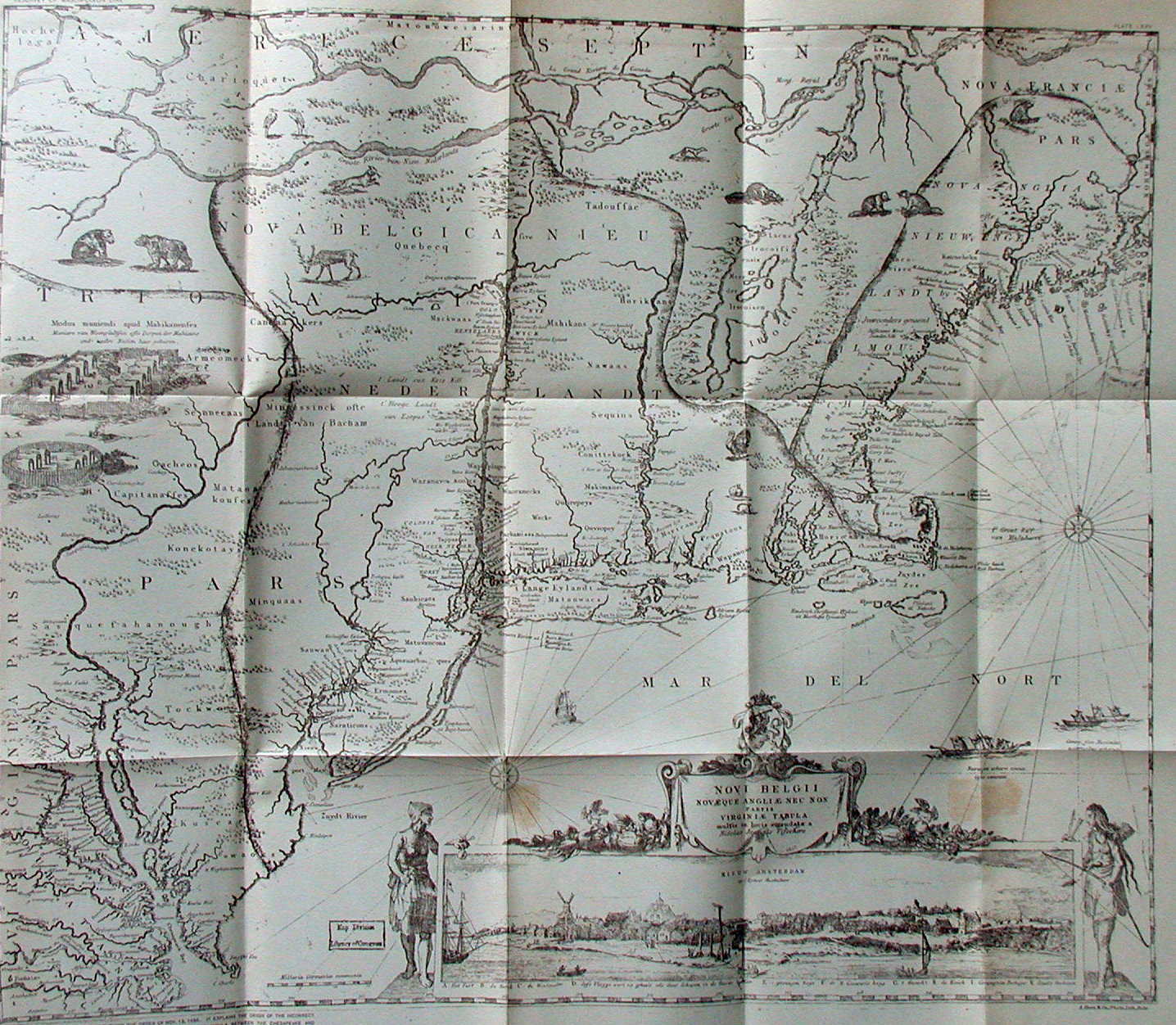
Now to the maps examined. In 1651, the very year Fort Kasimier was started, the Dutch publisher Jan Jansson issued a seminal map of the northeast. Titled Belgii Novi Angliae Novae et Partis Virginiae, this map would be copied by mapmakers for the next hundred years. The map appeared too early to show Fort Kasimier; but did show a large circular Susquehanna River Indian fort at about latitude 42 degrees, and a rectangular one further north. This is the first appearance of such a fort on a map, although John Smith's 1612 map of Virginia had indicated several Indian villages along the Susquehanna by small houses. Four years later, Nicolas Visscher issued his version of Jansson's map titled Novi Belgii Novaeque Angliae nec non Partis Virginiae Tabula. This map is known primarily from its second state issued in 1656, which shows Fort Kasimier. Like the original Jansson map, it includes the Indian fort at forty-two degrees. Also, like the Jansson map, it contains an egregious error, naming the western cape of Delaware Bay Cape Cornelius, and locating Cape Henlopen many miles south. The boundary between Delaware and Maryland came to depend upon the location of this cape. [14] Since Delaware was part of Pennsylvania in colonial times, this boundary also was involved in the Maryland-Pennsylvania boundary dispute. A copy of Visscher's map used in the dispute contains Penn's handwriting. [15] It says something of the times that this Visscher map, twenty-five years old in 1681, would still be used to settle an important boundary dispute, and some conjecture this was done at Penn's insistence to gain more territory. The note by Penn on the back reads as follows: 'The Map by which the privy Council 1685 settled the (the) Bounds between the Lord Baltimore & I, & Maryland & Pennsylvania & Territorys or annexed Countys W P.' [16] A version of Visscher's map by Hugo Allardt, another Dutch mapmaker, is in the Blathwayt Atlas. The Jansson-Visscher series of maps locate the fortieth parallel about 15 miles north of New Castle Town.
Dutch cartographers were pre-eminent in the seventeenth century and a number of sea atlases were published from the 1650s on that contain charts of the Delaware Bay area. The earliest one of interest came in 1656, Zee-Atlas, ofte Water-Wereldt by Arnold Colom. His chart of the mid-Atlantic coast was titled Pascaarte van Nieu Nederlandt . This chart, with similar title, was updated and used by Hendrick Doncker in 1660, Joannes van Loon in 1661, Jacob Colom (Arnold's father) in 1663, and Peter Goos in 1666. The Colom and Doncker charts do not locate Fort Kasimier, but the van Loon and Goos charts do. Like the Jansson-Visscher maps, these Dutch charts locate the fortieth parallel about 15 miles north of Fort Kasimier. Goos also produced a larger scale chart of the Hudson and Delaware Bay area (essentially a map of New Jersey) titled Paskaerte van de Zuydt en Noordt Revier in Nieu Nederlant; however, this chart is rare and unlikely to have been seen by either Penn or British government officials. [17] It locates 'Fort Kasimiris' 40 miles south of the fortieth parallel, but this is due to a misplacing of the fort. The parallel itself is (nearly) correctly shown as passing just north of the mouth of the 'Schuyl Kill.'
The English seized the Dutch colonial empire along the Hudson and Delaware Rivers in 1664, and Dutch mapmakers had little commercial reason to improve maps of the area afterward. The Jansson-Visscher maps continued to be published with modest improvement and the original Colom chart with its Doncker and Goos improvements also continued to appear in Dutch atlases until late in the century. The Dutch retook their colony from the British in 1673 but the British regained control in 1674.
English colonial maps began to appear in the 1670s. John Ogilby published a Jansson-Visscher map in his book America in 1671. It was titled Novi Belgii quid nunc Novi Jorck vocatur, novae qz Angliae & partis Virginiae accuratissima et novissima delineatio. The map came from a plate used for the Amsterdam publication De nieuwe en onbekende weereld by Arnoldus Montanus.[18] Like the other Jansson-Visscher maps, this one also locates the fortieth parallel about 15 miles north of New Castle Town. Ogilby also included in his book a revised version of Lord Baltimore's map of 1635. However, New Castle Town is not shown and the Delaware River is too crudely drawn to place it accurately. Ogilby did revise the map to move the fortieth parallel farther north relative to the head of Chesapeake Bay, which indicates a general knowledge that the parallel lay farther north.
Augustine Herrman's printed map titled Virginia and Maryland appeared in 1673, although manuscript copies had apparently circulated since about 1670. This remained the most accurate map of the Chesapeake and Delaware Bay region until the eighteenth century. Herrman was born in Prague and was a man of many parts.[19] One of his drawings of New Amsterdam (New York) was engraved on the Visscher map of 1656. He was involved in numerous boundary negotiations between Maryland, Virginia, and the Dutch and Swedes along the Delaware. He made observations, drawings, and maps during his travels and proposed to make a map of Maryland for Lord Baltimore in return for land. The map was finished around 1670 and sent to England to be engraved and published in 1673. Lord Baltimore was very pleased and Herrman received his land on the upper Chesapeake near Elk River, which he called Bohemia Manor. William Penn corresponded with Herrman upon his arrival in America, as mentioned above. Herrman's original map was published in four sheets, though one-sheet versions are commonly seen in reproduction. He locates the fortieth parallel about 30 miles north of New Castle Town, and runs it through the 'Sassquehana Indian Fort', located well up the Susquehanna River at 'Canooge.' Since Herrman's map was prepared under the aegis of Lord Baltimore who insisted his line ran through this fort, both Penn and British government ministers, in light of other maps, may have discounted its latitudinal markings at the time. The Herrman map is either the source or the confirmation of Lord Baltimore's claim that his line ran through the Susquehanna Indian fort. This palisade Indian fort was distinctive enough to be a landmark.[20] The Susquehannock Indians occupied it and likely built it for protection from the Iroquois who lived on the upper reaches of the river. It did them no good, and by 1680 they were gone.
Sometime circa 1675, John Seller issued A Mapp of New Jarsey , the first map of this state alone.[21] It shows both Delaware and Hudson Bay, but not the Chesapeake. New Castle Town is not shown but can be approximately located from the shoreline detail. It lies roughly 30 miles south of the fortieth parallel, so the map follows Herrman's latitude marking. A second version was published in 1677 by John Seller and William Fisher and is in the Blathwayt Atlas.This map contains promotional text along the bottom to encouraged settlement and it was apparently ordered by Penn and other Quakers to encourage land settlement at the time of their acquisition of land in West Jersey. 'Penn's experiences in this connection were to be valuable to him later in the founding of Pennsylvania.'[22]
In 1676, Thomas Bassett and Richard Criswell published an edition of John Speed's The Theatre of the Empire of Great Britain. Speed himself was long dead, but books under his name with new maps continued to appear. Bassett and Criswell combined Speed's The Theatre... with his A Prospect of the Most Famous Parts of the World in their 1676 publication. This latter book contained a map in the Jansson-Visscher series titled A Map of New England and New York, which shows New Castle about 15 miles south of the fortieth parallel. Another map included was A Map of Virginia and Maryland prepared by Francis Lamb. The map is a derivative of the Herrman map, but has an important difference; it shows New Castle Town only about twelve miles from the fortieth parallel, though the parallel is still shown going through the 'Sussquehana Fort.'
Also in 1676 appeared A map of New England New Yorke New Iersey Mary-Land & Virginia by Robert Morden and William Berry, which is in the Blathwayt Atlas. It shows New Castle Town about twelve miles south of the fortieth parallel. This map is sometimes considered to be in the Jansson-Visscher series because it uses the title cartouche from the Ogilby map, but it has a distinctly different look, and shows the entire Chesapeake Bay.
There is a manuscript map in the Public Record Office, London, that derives from Herrman's map of 1673, and has been dated circa 1677. It is very similar to another manuscript map in the Blathwayt Atlas, and both maps are copies from the same original. A description of this map says the following: 'The very mention of the fortieth parallel has special significance to anyone familiar with the origins of William Penn's Pennsylvania grant of 1681, in which the location of his southern boundary at forty degrees became the basis of conflict over the northern boundary of Lord Baltimore's Maryland colony. From the beginning Penn had a misconception as to the location on the ground of this parallel, the source of which has never been satisfactorily explained. If the Public Record Office Maryland manuscript was made in 1677, it is not impossible that it came to Penn's notice when he was first planning to obtain a colonial grant, and it could have been a factor in forming the mistaken geographical ideas that were sponsored by him and were first publicized in his map of Pennsylvania. It may be that the ineptitude of an anonymous copyist, who did not have a sheet of vellum of the proper size, influenced the course of history.'[23] These manuscript maps have New Castle Town three miles south of the fortieth parallel, and yes, the ineptitude of a copyist may be to blame, but for a different reason as will be discussed below.
Sometime circa 1678, John Thornton and Robert Green issued A Mapp of Virginia, Mary-Land, New-Jarsey, New-York & New England. It shows New Castle Town about 10 miles south of the fortieth parallel. This important map is in the Blathwayt Atlas and will be discussed further below.
Finally, in 1679 Richard Daniel engraved A Map of ye English Empire in ye continent of America viz Virginia Mary Land Carolina New York New Iarsey New England &ct. This map was sold by Robert Morden and William Berry, and was issued again around 1685 with Pennsylvania added to the list of colonies. This map shows New Castle Town about 10 miles south of the fortieth parallel.
The table below summarizes the maps discussed above with the distance and position of New Castle Town relative to the fortieth parallel that they show.
| Table 1. Comparison of Latitude Markings | ||
| Map Date | Mapmaker and Map | New Castle Town relative to 40 N |
| 1656 | Visscher:Novi Belgii Novaeque Angliae | 15 miles south |
| 1666 | Goos: Pas Caerte van Niev-Nederland | 15 miles south |
| 1666 | Goos: Paskaerte van de Zuydt | 40 miles south |
| 1671 | Ogilby:Novi Belgii quod nunc Novi Jorck | 15 miles south |
| 1673 | Herrman:Virginia and Maryland | 30 miles south |
| 1675 | Seller:A Mapp of New Jarsey | 30 miles south |
| 1676 | Speed/Bassett & Criswell/Lamb:A Map of Virginia and ... | 12 miles south |
| 1676 | Morden&Berry:A Map of New England New Yorke | 11 miles south |
| 1676 | Speed/Bassett & Criswell: A Map of New England and ... | 15 miles south |
| 1677 | Public Record Office/Blathwayt Atlas manuscript maps | 3 miles south |
| 1678 | Thornton&Green: A Mapp of Virginia, Mary-Land | 10 miles south |
| 1679 | Daniel: A Map of ye English Empire | 10 miles south |
| 1681 | Thornton&Seller:A Map of some of the South and East Bounds of Pennsylvania | 20 miles north |
| 2003 | Modern map | 24 miles south |
| The distances given were calculated by dividing the measured distance to the 40th parallel on the map by the distance between parallels and multiplying by 69.5 miles per degree. | ||
All of these maps show New Castle Town anywhere from 3 to over 30 miles south of the fortieth parallel, the true distance is about 24 miles south. Only the 1681 Pennsylvania map shows the town to be north of 40 degrees, and by 20 miles!
The Pennsylvania grant assumed the fortieth parallel lay within twelve miles of New Castle Town on the Delaware. The Public Record Office/Blathwayt Atlas manuscript maps show it to be three miles. The Speed map of 1676, the Morden & Berry map of 1676, the Thornton & Green 1678 map, and the Daniel map of 1679 all show this distance to be roughly twelve miles. It is also known that the Visscher map 0f 1656 was later used in locating Cape Henlopen and in setting the Maryland-Delaware southern boundary, and has Penn's handwriting. This map shows Fort Kasimier (founded in 1651 and which became New Castle Town) to be about 15 miles south. Thus, in light of what all these maps show, Penn and the British government officials were reasonable in thinking the fortieth parallel lay about twelve miles north of New Castle Town when drafting the Pennsylvania Charter.
Why twelve miles for the circle around New Castle? The Duke of York originally suggested 20 to 30 miles north of New Castle for the limit of Penn's grant and he was right if the forty-degree boundary line ran to the Delaware. Penn objected and suggested twelve miles, probably based upon some of the maps mentioned above.[24] A more prosaic explanation is that the average width of the Delmarva Peninsula down to Cape Henlopen (where it rapidly widens) is about 24 miles. Thus, the government was inferentially halving the peninsula between Maryland and the Duke of York (and subsequently Penn) lands along the Delaware, although this solution only became accepted later within the context of the Maryland-Delaware boundary settlement. This also may be why the government ministers decided to go along with Penn's suggestion of twelve miles.
The twelve-mile circle around New Castle was important to Penn because he wanted to own the riverbank as far south as possible for port facilities. In fact, Penn subsequently petitioned the Duke of York to add the 'Lower Counties' of New Castle, Kent, and Sussex (the future Delaware) to his patent for this reason. This petition was granted in August, 1682.
Explaining the 1681 Map.
The latitude on the 1681 Thornton & Seller Pennsylvania map is an anomaly within the cartography of the time, and the subsequent time, effort, ill-will and expense in litigating the Maryland-Pennsylvania boundary made it a costly anomaly. How did this incorrect latitude get on the map? It is usually assumed that the 1681 map is based upon the 1673 Herrman map because of the detail in the upper Chesapeake and Delaware Bay. None of the prior maps had such detail. But suppose it is based upon another map prepared between 1673 and 1681. Such a map is the circa 1678 map of Thornton and Green. At least three versions of this map exist. Two date sometime between 1673 and 1681 with minor differences, another dates circa 1685 and is similar except for added names, among them Pennsylvania and Philadelphia. [25] A comparison of this Thornton map with the Herrman map clearly shows the two are related. Now compare the detail in the upper Chesapeake and Delaware on these two maps (Herrman , Thornton ) with the 1681 Pennsylvania map. The Pennsylvania map more closely resembles, especially along the Delaware, the 1678 Thornton & Green map. This resemblance has been noted before. 'The eastern shore of Delaware Bay and Delaware River as delineated on the Penn map do not derive from the map of Augustine Herrman. In both outline and nomenclature this section closely resembles A Mapp of Virginia, Mary-land, New Jarsey, New-York & New England.'[26]
Now, there is something different about this 1678 Thornton & Green map. It has a set of grid lines that do not correspond to latitude and longitude. Such grid lines, called squaring lines, were put on maps as engraving aids for reducing or enlarging when copying maps. Usually they were then removed, and their retention has been identified as a characteristic of the 'Thames school' of mapmakers of whom Thornton was one. The degree markings were added external to the frame of the map later. A close look shows that the fortieth parallel line on the Pennsylvania map, which is also the bottom of the map, matches a grid line on the 1678 map. Here is the conjecture. The mapmaker (Thornton or his apprentice?) framed the Pennsylvania map working from the 1678 map. He either used a copy without the external latitudinal markings or forgot about them. Subsequently, when finishing the map, he thought his bottom framing line was the fortieth parallel when it was not, but a mapmaker's squaring line. Alternatively, a different mapmaker finished the map without realizing the grid line was not a parallel. This is admittedly a conjecture, but it is the only explanation known for this anomalous latitudinal marking within the context of the contemporary cartography. A marking that had great consequence.
Whether the explanation above for the map anomaly is true or not, another question remains. Why did Penn believe this one map as opposed to all the others and his own Charter? Penn was a professional courtier, politician, and organizer, and no stranger to sharp dealing in land. He had acquired land in New Jersey and been involved in its partition into East and West Jersey in 1676. He was a friend of the Stuart court and used his connections despite his wayward religious beliefs as viewed by the court. He certainly took advantage of Lord Baltimore's lesser political skills in the Maryland-Pennsylvania-Delaware boundary dispute. Setting Delaware's southern boundary was another instance where Penn insisted on the use of an incorrect map to further his own interests. Why else use the old 1656 Visscher map to incorrectly identify Cape Henlopen when later English maps (the 1678 Thornton & Green map discussed above, for example) correctly placed the cape at the western entrance to Delaware Bay? Thus, in two instances Penn used an incorrect map for further land acquisition when better and more accurate maps were available. Once may have been honest confusion, twice indicates a particular frame of mind. But, this is a story about Pennsylvania maps, not William Penn, and Penn was not responsible for the errors on the maps.
Now for some of the names and markings placed on this first map of Pennsylvania. Going north from 'New Castle' there is: 'Wid: Block,' 'Christian Cr.,' 'Brandewine Cr.,' 'three Tree Pt.' All of these locations are within present day Delaware. Next come: 'Marcus Pt.' (Marcus Hook), 'Rob Wader Plt,' 'Vpland' (Chester), 'Prester Cr,' 'Tenekum Isle,' and 'SkooleKil' denoting the river. A ways up the river is 'Peter Ambos.' Then continuing up the Delaware: 'Peter Coks,' 'Wicoco,' 'Shakamakse,' 'Gunner Ambo,' 'Tokoune,' 'Rich Noble,' 'Peter Aldrix,' 'Matincunck I,' 'St Passe I,' 'Manahe,' 'Old Indian field,' 'Falls.' Some of these are settlers' names; Peter Coks is probably the Dutch settler from whom Penn purchased land for Philadelphia.[27] Others are Indian tribes and others are landmarks. There are no settlements along the Susquehanna except for the 'Susquahana fort Demolished,' the other names are apparently Indian names for creeks. None of the maps of this time show settlement north up the Susquehanna River. This 1681 Pennsylvania map has omitted some of the Dutch and Swedish settlements along the Delaware that appear on earlier maps (such as Finlandt, Gottenburgh). However, it also includes names, particularly the settler names, missing on other maps. Thus its maker had access to detail on settlement in the area not on other maps. Some of this information likely came from the expedition of James Wasse. The 'Quintipartite Deed' of July 1676, divided New Jersey (or Jarsey as it was called at the time) into East and West. Penn and Quaker associates were proprietors of West Jersey and they appointed three commissioners, including Wasse, to provide them with information on the lay of the land. A report, if prepared, has never been found but the additional detail along the Delaware River on maps from this time on likely came from this initiative. [28] The 1678 Thornton & Green map contains three instances of Wasse's name and this has been used, in part, to date the map. Since this map does not contain the latitudinal error of the 1681 Pennsylvania map, it cannot have been the source of that error.
If this first Pennsylvania map was made for advertisement, as it apparently was, then its maker accomplished the purpose. He indicates settlement and actual settlers in the area so land buyers would not feel as though they were entering a wilderness. He also leaves three fourths of the map empty so people could see there was a lot of land to buy. But, for a professional mapmaker, he made an unforgivable error.
[1] Soderlund, Jean R. (Ed.), Dunn, R. S. & M. M. (Gen. Eds.), William Penn and the founding of Pennsylvania 1680-1684: A Documentary History, University of Pennsylvania Press, Philadelphia 1983. Document #1 Petition to Charles II, May? 1680. The complete text is a partial reconstruction.
[2] Soderlund, Document #11 The Charter of Pennsylvania, March 4 1681.
[3] Papenfuse, E. C. & Coale III, J. M., The Hammond-Harwood House Atlas of Historical Maps of Maryland, 1608-1908, The Johns Hopkins University Press, Baltimore 1982, page 5.
[4] Soderlund, Document #12 To Robert Turner, March 5 1681.
[5] Soderlund, Document #24 Additional Instructions to William Markham, October 28 1681.
[6] Black, Jeannette D., The Blathwayt Atlas: Volume I The Maps (1970), Volume II Commentary (1975), Brown University Press, Providence, Map #15. The original Blathwayt Atlas is at the John Carter Brown Library in Providence. It apparently belonged to the Blathwayt family until appearing on the auction market in 1910. Volume I is a large double folio reproducing the maps; Volume II is a text commentary. The 1681 Pennsylvania map is also reproduced in the Pennsylvania Magazine of History and Biography, 1924; in Mercator Society Publication Number One, English Mapping of America 1675-1715, The New York Public Library 1986; and a portion is reproduced in Soderlund.
[7] Soderlund, Document #15 Some Account of the Province of Pennsylvania, 1681. This is the complete text of Penn's pamphlet.
[8] Kane, Harriet F., 'Notes on Early Pennsylvania Promotion Literature,' Pennsylvania Magazine of History and Biography, Vol. 63 (1939) pp. 144-167. This article gives a conjectured order of publication for Penn's promotional literature, but does not reproduce it.
[9] Ford, Worthington C., 'The First Separate Map of Pennsylvania,' Proceedings of the Massachusetts Historical Society, November, 1923, pp. 172-183. The text of A Brief Account as it appears on the map is reproduced.
[10] Ford, page 175; also Kane, pp. 146-147.
[11] Mathews, E. B., 'History of the Boundary Dispute Between the Baltimores and Penns Resulting in the Original Mason and Dixon Line;' contained in Report on the Resurvey of the Maryland-Pennsylvania Boundary, part of the Mason and Dixon Line, Department of Internal Affairs, Harrisburg Publishing Co., State Printer, Harrisburg 1909. Mathews gives a complete chronology of the boundary dispute and includes a copy of Lord Baltimore's 1635 Maryland map.
[12] Soderlund, Document #20 To Planters in Maryland, September 16 1681.
[13] Soderlund, Document #3 Lord Baltimore's Agents to William Blathwayt, June 23 1680.
[14] Wainwright, Nicholas B., 'Tale of a Runaway Cape: The Penn-Baltimore Agreement of 1732,' The Pennsylvania Magazine of History and Biography, Vol. 87, No. 3 January 1963 pp 251-293. Also see Mathews.
[15] See Mathews, the map is a foldout opposite page 142. This map is also reproduced in many other map histories. An interesting discussion on the peregrinations of the copy with Penn's note is given by Mathews in a footnote on page 165: 'The map used before the Privy Council in 1685, with autograph note by W. P., was offered in the Coleman (a London book dealer) sale of 1870 along with the Penn MSS. purchased by the Pennsylvania Historical Society. It was subsequently listed by Allen in 1872 and by Ellis in 1883 (book dealers). Since this report was written this old map has reappeared in the market. Messus. Dodd, Mead & Co., who offer it in their catalogue of April, 1908, write that it is now owned by a foreign correspondent, who gained possession of it about 1904. Although the price of the map in the meantime has materially increased it is to be hoped that some library like that of the Pennsylvania Historical Society may secure it, since it is the means of disproving one of the most serious charges against the Penns during the entire controversy.' The map is now in the John Work Garrett Library in Baltimore. The charge referred to is that Penn was dishonest in his dealings with Lord Baltimore. He certainly took advantage of Lord Baltimore's lesser political skills; whether that is dishonesty can be left to his biographers.
[16] A photograph of Penn's inscription on the back of the map appears on page 38 in Papenfuse & Coale.
[17] Burden, Philip, The Mapping of North America, A List of Printed Maps 1511-1670, Raleigh Publications, England 1996. The chart is #388 in Burden who says it is rare and not in most copies of Goos' atlases. All of the other Dutch charts mentioned are described and illustrated in Burden.
[18] McCorkle, Barbara, New England in Early Printed Maps 1531 to 1800, The John Carter Brown Library, Providence 2001. Map #671.1.
[19] Kansky, Karel J., 'Augustine Herman: The Leading Cartographer of the Seventeenth Century,' Maryland Historical Magazine, Vol. 73 No. 4, December 1978, pp. 352-359.
[20] The location of this fort is discussed in Chapter 2 of Hanna, Charles A., The Wilderness Trail; or, the ventures and adventures of the Pennsylvania traders on the Allegheny Path, with some new annals of the old West, and the records of some strong men and some bad ones, G. P. Putnam Sons, New York 1911. Hanna locates it in Lower Windsor Township, York County, across the river from the town of Washington, or almost precisely on the fortieth parallel just as Herrman said.
[21] This map is discussed in Snyder, John P., The Mapping of New Jersey, Rutgers University Press, New Brunswick, New Jersey 1973, pp. 20-22; where it is dated 1675. Three versions of the map are reproduced in Tooley, R. V. (Ed.) The Mapping of America, Holland Press, London 1985; where the map is discussed by Tony Campbell in Chapter 8 as a Jansson-Visscher derivative.
[22] Black, Vol. II, page 89.
[23] Black, Vol. II, pp. 109-118. The Public Record Office manuscript map is reproduced in Swift, Michael, Historical Maps of North America, PRC Publishing Ltd., London 2001, page 29.
[24] Mathews, page 236.
[25] Stevens, Henry & Tree, Roland, Comparative Cartography, chapter 2 in Tooley, R. V. (Ed.) The Mapping of America, Holland Press, London 1985. The map is #88.
[26] Black, Vol. II, page 104.
[27] Soderlund, Document #56 Laying Out Philadelphia Lots, March 17, 1683. These are letters between Holme and Penn.
[28] Black, Vol. II, page 76-78.
Copyright 2003 by Harold Cramer. All rights reserved.