The maps from around 1900 to
the 1930's look much the same.
 |
1920
NORDOSTSTAATEN DER NORDAMERIKANISCHEN UNION, Bearb. V. H.
Mielishch U. E. Umbreit. Flachentreuer Azimutaler Entwurf.
Lithogr. V. M. Grosse, O. Kehr U. G. Kirchner, dated
April 1920. This map is plates 97 and 98 from a German
atlas published in the early 1920s. The northeast is
shown from Vermont to Indiana and south to Kentucky;
Pennsylvania is at the center. Longitude from Greenwich,
blank verso. Scale: 1 inch = 47 miles. Size: 20 x 15
inches. |
 |
1921
PENNSYLVANIA - showing counties in different colors -
townships - cities - boroughs - villages - post offices...,
published by the National Map Co., Indianapolis. The map
is undated but references the 1920 census and likely
dates circa 1921-25, only the mid-part is shown here.
This huge map, 48 x 60 inches, includes an inset with
Congressional Districts and a gazetteer of cities and
towns with population along the bottom and on the verso.
Main roads are crudely shown in broad red lines without
route numbers, as the
detail
shows, which likely dates it
earlier than 1925. Rail and electric lines are also shown.
The maps folds into a 8.5 x 6 inch black cover. Scale: 1
inch = 5.2 miles. |
 |
1922
NORTH-EASTERN STATES, Plate 93 from the 1922 edition
of the Times Atlas, prepared at the Edinburgh
Geographical Institute under the direction of J.G.
Bartholomew, the well-known British cartographer.
This map shows the Mid-Atlantic states west to Indiana,
including New York, Pennsylvania, Delaware, Maryland,
Virginia, Ohio, West Virginia, and parts of surrounding
states. It is blank on the verso save for title and index.
Longitude west from Greenwich. Scale: 1 inch = 40 miles.
Size: 16 x 22 inches. |
 |
1923
PENNSYLVANIA, from the 1923 Atlas of the World and
Gazetteer, published by Funk & Wagnalls Co., NY,
copyright C. S. Hammond & Co. This small map comes
from an atlas of over a hundred maps which complemented
the famous Funk & Wagnalls encyclopedias. For those
of a certain age, the phrase "look that up in your
Funk & Wagnalls" brings a smile. Size: 9.5 x 6.5
inches. |
 |
1924
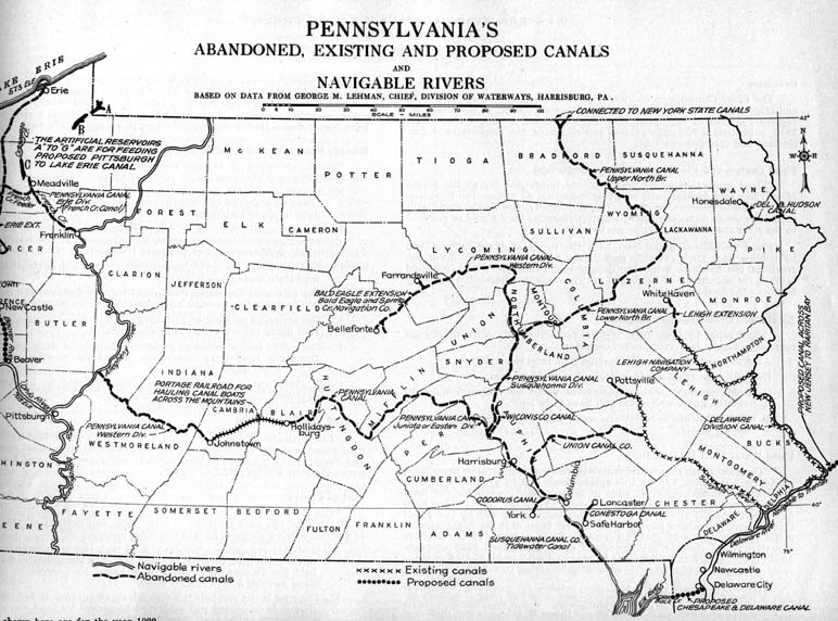
PENNSYLVANIA'S ABANDONED, EXISTING AND PROPOSED CANALS
AND NAVIGABLE RIVERS, from The Smithsonian Institution's
Study of Natural Resources Applied to Pennsylvania's
Resources by Samuel S. Wyler, Smithsonian Institution,
Washington, August 1924. This map comes from a 182 page
book containing information on natural resources,
agriculture, and transportation displayed by using maps.
This particular one shows a long forgotten means of
transport, the canal system. In 1924 the Chesapeake and
Ohio Canal that ran from Cumberland to Washington along
the Potomac went out of business, so it is a little
ironic for this map to talk about 'proposed' canals. |
 |
1925
PENNSYLVANIA, a map puzzle with Hammond's standard map of
the state printed on quarter-inch cardboard. Each piece
is a county with smaller counties combined on one piece.
The outline of each piece can be clearly seen. Scale: 1
inch = 28 miles. Size: 8 x 11 inches. |
 |
1926
POST ROUTE MAP OF THE STATE OF PENNSYLVANIA SHOWING POST
OFFICES WITH THE INTERMEDIATE DISTANCES ON MAIL ROUTES IN
OPERATION ON THE 1st OF DECEMBER 1926, published by order
of Postmaster General Harry S. New. Compiled and drawn by
C. F. Hohoff. This postal map was apparently printed by
the government. It is in two large sections, each 41 x 36
inches, and shows rail lines with the distances between
post offices; roads are not shown. The eastern section,
part of which is shown here, has the title and insets of
Pittsburgh and Philadelphia. The western section begins
at the Potter to Franklin County meridian. Blank verso.
Scale: 1 inch = 5 miles. |
 |
1927
PHYSICAL AND POLITICAL PENNSYLVANIA, from Essentials
of Geography Second Book Part One Revised Edition with
Pennsylvania Supplement, by A. P. Brigham & C. T.
McFarlane, American Book Co., New York 1925. The map is
from an appended 32 page Pennsylvania section by J. R.
Smith & J. H. Willits copyright 1927. It is a double
page spread showing counties, towns, and elevations by
color. Size: 10 x 16 inches. |
 |
1928
THAYER'S INDUSTRIAL MAP OF PENNSYLVANIA, published by the
Reyaht Co., Butler, Penna., built with the aid of
Professor James Roscoe Huston, copyright 1928. This is a
large folding wall map with paper squares pasted on linen
with gaps at the folds so the paper does not wear; the
eastern section with title is shown here. Local
industries such as steel, coal, lumber, etc. are marked
in red as the
detail
shows. There are insets of
Philadelphia and Pittsburgh and major roads are named,
such as the Lincoln Highway, and indicated by heavy brown
lines. County boundaries and towns are indicated, but
little geographic detail. Thayer industrial maps also
have been seen for Europe and the United States. Scale: 1
inch = 5 miles. Size: 40 x 65 inches. |
 |
1929
STEAM RAILROAD MAP OF PENNSYLVANIA, issued by the Public
Service Commission 1929; J. W. Clement Co., Matthews-Northrup
Works, Buffalo, N. Y. This large folding map is the late
twenties version of the J. Sutton Wall state produced
railroad maps from the turn of the century, now farmed
out to a private contractor. Sound familiar? It has
insets of Pittsburgh and Philadelphia at top, with rail
lines identified by color code, as the
detail
shows. Scale: 1 inch = 6 miles.
Size: 35 x 56 inches. |


